| ← Back | Next Falls → |
Avalanche Creek Falls, Arthur's PassWaterfall Seasons - The Waterfall Guide
Avalanche Creek Falls is only a short stroll from the main road road running through the Arthurs Pass village, making it the easiest
waterfall to access in the Arthur's Pass National Park. Arthur's Pass is only a tiny village and it starts to shut down fairly early in
the evening, with very little commercial activity after dark. Fortunately one of the features in the town that remains open at night is
Avalanche Creek Falls, so bring a torch, follow the dimly lit trail and take the opportunity to see the falls under very different
viewing conditions.
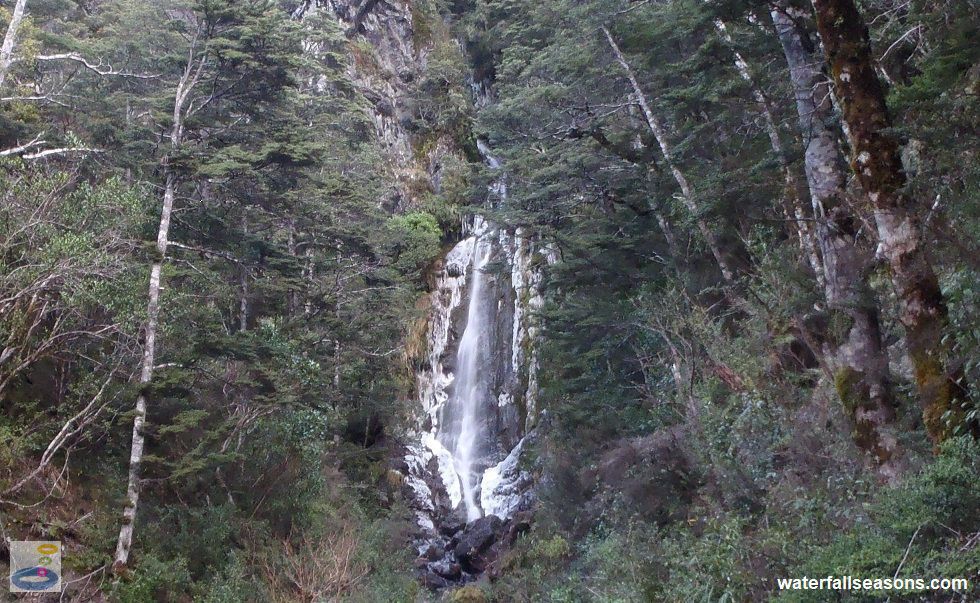
 Above: Avalanche Creek Falls from the viewing platform
(Order this image)
You can reach the falls from the trail behind the visitor centre or by walking up the hill next to the chapel, as described below under the Essential Information section. If you are coming up from the chapel, look out for the walking boot mounted onto a memorial stone.
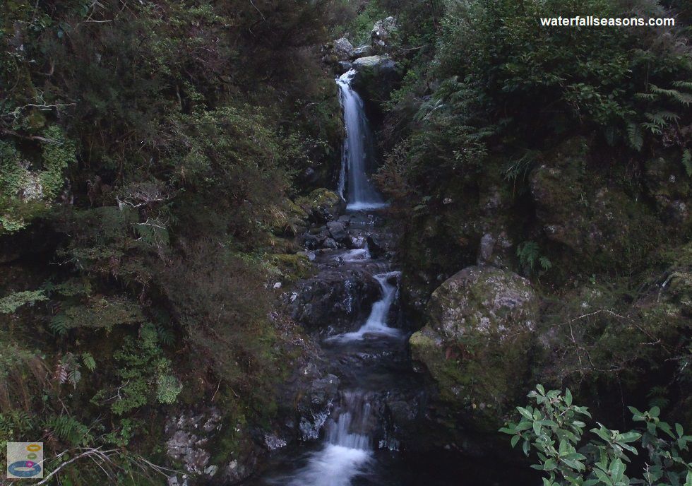
If you are coming from the visitor centre, you will need to cross Avalanche Creek via a little stone arch bridge. As you lean over the
bridge's stone wall, the view of the cascades here is so enchanting that you might be mistaken into thinking that these are the
Avalanche Creek Falls. However, the falls themselves are about 100 metres further upstream and out of view from the trail head here.
 Above: The cascades downstream of Avalanche Creek Falls
(Order this image)
At night, the path here is through a very short but dark section of forest with only a single lamp on one of the bends, so BYO torch. A spotlight underneath the viewing platform shines up the creek gully towards the falls, about 50 metres into the distance. The forest at night is still, apart from the sound of the gently rushing water. When mist descends down onto the village it creates an eery sense of isolation, despite being quite close to the main road.
You cannot access the base of the falls at night, but if you return during the day with a pair of sturdy
shoes you can scramble up the creek bed during low flows to get a closer view. In winter, I found the falls fringed with ice, but the water
was still flowing strongly.
Here is a quick video of the falls in winter, including a late afternoon visit, and a visit after dark when I was the only one around.
View Larger Map
 Above: Avalanche Creek Falls from the viewing platform
(Order this image)
You can reach the falls from the trail behind the visitor centre or by walking up the hill next to the chapel, as described below under the Essential Information section. If you are coming up from the chapel, look out for the walking boot mounted onto a memorial stone.
 Above: The cascades downstream of Avalanche Creek Falls
(Order this image)
At night, the path here is through a very short but dark section of forest with only a single lamp on one of the bends, so BYO torch. A spotlight underneath the viewing platform shines up the creek gully towards the falls, about 50 metres into the distance. The forest at night is still, apart from the sound of the gently rushing water. When mist descends down onto the village it creates an eery sense of isolation, despite being quite close to the main road.
Here is a quick video of the falls in winter, including a late afternoon visit, and a visit after dark when I was the only one around.
Your Seasonal Guide:
| Best Time of Year to Visit: | Best Time of Day to Visit: |
|---|---|
| Streamflow data is not locally available for this river, but based on available rainfall information, there is likely to be reliable flow over the falls all year round, with flows evenly spread throughout the year. | Visit at night when the forest is dark and the falls are illuminated. |
Other Information Before You Go:
Location: 81 West Coast Road (State Highway 73), Arthur's Pass National Park, Arthurs Pass,
and 150 km (approx. 2 hour drive) north west of the Christchurch city centre.
Latitude:-42.940479 Longitude:171.560583
Getting there: From Christchurch head along the State Highway 73 through Sheffield and Springfield up to Arthur's Pass. In Arthur's Pass, you can reach the start of the 50 metre trail (part of the Millennium Walk) to the falls from behind the northern side of the Arthur's Pass Chapel, or by following the gravel path that runs behind the visitor centre. Parking is available in the main street near the chapel or at the visitor centre.
Water source: Avalanche Creek
Approx. height: Difficult to estimate, as the top of the waterfall is obscured from view, but I estimate the visible section to be approximately 20 metres high. The cascades downstream are a 3-5 metres high.
Approx. width: 1-5 metres
Approx. length: 5-10 metres, with a long flat section of around 50 metres between the main waterfall and the downstream cascades, which have a similar length of 5-10 metres.
Swimming available at the falls: No, as the base of the falls is not readily accessible, but you can paddle in the small pool at the base of the downstream cascades if you are prepared to clamber down the steep river bank.
Facilities: None at the falls. There is a car park and public toilet at the visitor centre, and a cafe in the main street near the start of the walk to the falls.
Entrance fee: None
Opening times: Always open
Sun shade: Shade available at the falls
Wheelchair access: None
Prohibitions including whether you can bring your dog: No dogs
Managing authority: NZ Department of Conservation
Nearby attractions: Devil's Punchbowl Falls and Bridal Veil Falls, on Punchbowl Road, roughly 500 metres north of town.
Before you head out, make sure you read the
waterfall safety information and check with the managing authority for any current change of conditions.
Latitude:-42.940479 Longitude:171.560583
Getting there: From Christchurch head along the State Highway 73 through Sheffield and Springfield up to Arthur's Pass. In Arthur's Pass, you can reach the start of the 50 metre trail (part of the Millennium Walk) to the falls from behind the northern side of the Arthur's Pass Chapel, or by following the gravel path that runs behind the visitor centre. Parking is available in the main street near the chapel or at the visitor centre.
Water source: Avalanche Creek
Approx. height: Difficult to estimate, as the top of the waterfall is obscured from view, but I estimate the visible section to be approximately 20 metres high. The cascades downstream are a 3-5 metres high.
Approx. width: 1-5 metres
Approx. length: 5-10 metres, with a long flat section of around 50 metres between the main waterfall and the downstream cascades, which have a similar length of 5-10 metres.
Swimming available at the falls: No, as the base of the falls is not readily accessible, but you can paddle in the small pool at the base of the downstream cascades if you are prepared to clamber down the steep river bank.
Facilities: None at the falls. There is a car park and public toilet at the visitor centre, and a cafe in the main street near the start of the walk to the falls.
Entrance fee: None
Opening times: Always open
Sun shade: Shade available at the falls
Wheelchair access: None
Prohibitions including whether you can bring your dog: No dogs
Managing authority: NZ Department of Conservation
Nearby attractions: Devil's Punchbowl Falls and Bridal Veil Falls, on Punchbowl Road, roughly 500 metres north of town.
Locality Map:
The marker indicates the approximate location of the start of the trail to the falls. If the map is not zoomed in locally, as can occur with some browsers, simply refresh this web page.
View Larger Map
Comments:
If you would like to leave a comment about this waterfall, please fill in the comment box below.
I'm particularly interested in your experiences after visiting, and any changes in conditions, etc.
All fields are required if you would like to see your comments appear on this website.
| ← Back | Next Falls → |
| Home Page | New Zealand |
| Safety Info | Map |
| List of Lists | Your Support |
| Feedback | Media |
|
|
|
|
|
|
|
|
|
|
© Brad Neal 2024. All rights reserved. Here are my
affiliate links and cookies policy and opportunities to provide support to Waterfall Seasons.