| ← Back | Next Falls → |
Cumberland Falls, LorneWaterfall Seasons - The Waterfall Guide
| Australia |
| Victoria |
| Regions of Victoria: |
| Melbourne |
| Nth East VIC |
| Western VIC |
| Gippsland |
| Other Information: |
| Safety Info |
| Map |
| Your Support |
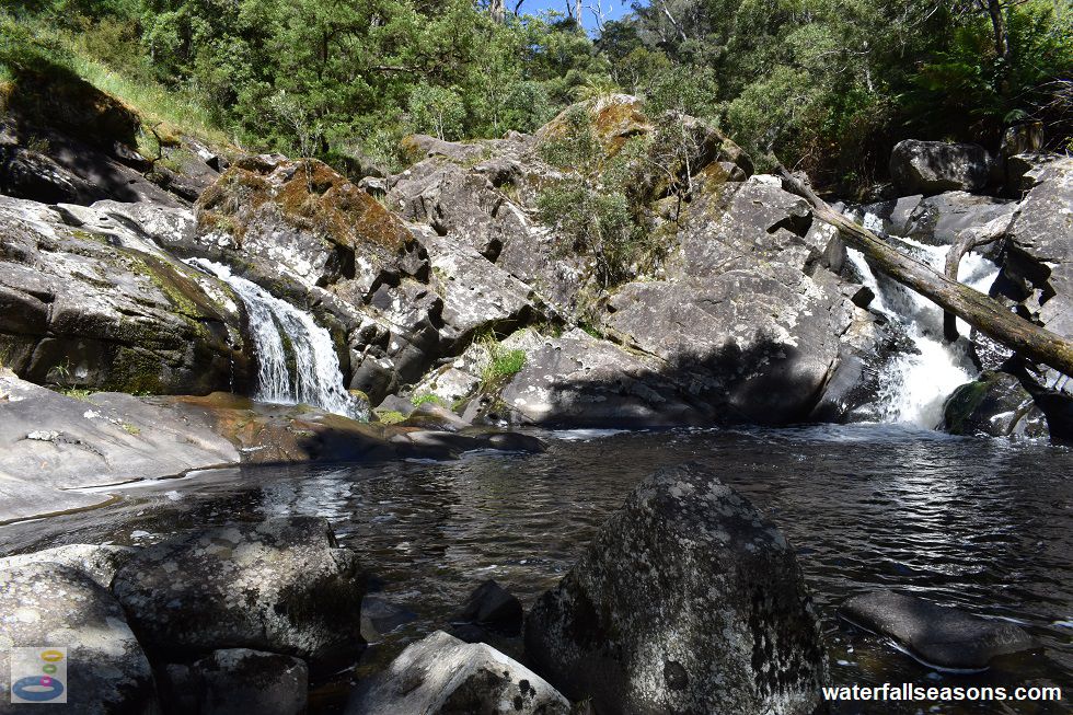
Cumberland Falls flows around a giant mound of exposed rock into a circular pool, several kilometres inland from Lorne in the Great Otway
National Park. These falls are only accessible during dry weather, with four river crossings along the walking track to the falls.
 Above: Cumberland Falls on the Cumberland River near Lorne
(Order this image)
The falls can be heard from some distance downstream, but first come into view when scrambling over the last hillock, from which there is a commanding view of the falls.
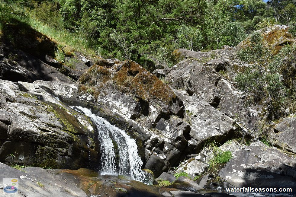
Find a comfortable boulder to sit on or wander around to the angled rock shelf on the southern edge of the waterfall pool to watch the two
streams of water flow into the pool - one gently flowing to the side in a delicate fan that spreads out over the rock shelf and one crashing its way
down over rocks and fallen logs as it announces itself on the centre stage. It is also possible to climb above the falls under dry conditions and
with extreme care on the slippery rocks near the water's edge.
 Above: The secondary waterfall segment at Cumberland Falls in the Otways
(Order this image)
Reaching these falls takes a little more effort than many on the Great Ocean Road, so you are more likely to be able to spend time in nature here without bumping into too many other people, particulalry once you get past Jebb's Pool.
The track was well maintained and in good condition when I visited, with the
river crossings of varying degrees of difficulty. The first and last crossings were relatively easy, but the second and third crossings were difficult to
traverse without getting at least one foot wet, so be prepared for this possibility.
View Larger Map
 Above: Cumberland Falls on the Cumberland River near Lorne
(Order this image)
The falls can be heard from some distance downstream, but first come into view when scrambling over the last hillock, from which there is a commanding view of the falls.
 Above: The secondary waterfall segment at Cumberland Falls in the Otways
(Order this image)
Reaching these falls takes a little more effort than many on the Great Ocean Road, so you are more likely to be able to spend time in nature here without bumping into too many other people, particulalry once you get past Jebb's Pool.
Your Seasonal Guide:
| Best Time of Year to Visit: | Best Time of Day to Visit: |
|---|---|
| Avoid higher flow periods in winter/spring and after heavy rainfall, when it can be dangerous to cross the river. The Cumberland River has not dried up completely in past summer/autumns, even in drought years. | Any time of the day is fine |
Other Information Before You Go:
Location: Cumberland River Holiday Park, Great Ocean Road, 7 km south-west of Lorne and 150 km (approx. 2 hr 15 mins) drive south west of the
Melbourne CBD. Cumberland Falls is part of the Great Otway National Park.
Latitude:-38.574700 Longitude:143.949000
Getting there: Lorne can be reached from either the Great Ocean Road (B100) or inland via Deans Marsh (C151). From Lorne, head south along the Great Ocean Road until you reach the Cumberland River Holiday Park. Park in the visitor car park and follow the instructions in the text above to reach the falls.
Water source: Cumberland River
Approx. height: 6-8 m
Approx. width: 2 m
Approx. length: 5 m
Swimming available at the falls: Yes, see my swim here
Facilities: None at Cumberland Falls or Jebbs Pool. There are picnic tables at the visitor car park, but no public toilets. If you are staying at the holiday park, there are a range of facilities available.
Entrance fee: None
Opening times: Always open except during high river flows when the track is unpassable
Sun shade: Shade available over the pool in the morning and middle of the day. Limited shade in the afternoon and around the edge of the pool.
Wheelchair access: None
Prohibitions: No dogs, removal of firewood prohibited
Managing authority: Parks Victoria
Nearby attractions: Jebbs Pool, roughly 2 km to the south along the same walking track.
Before you head out, make sure to read the
waterfall safety information and check with the managing authority for any current change of conditions.
Specific to this site, the managing authority advises against trying to walk to the falls when river levels are high,
and recommends "experienced walkers only from Jebbs Pool" to Cumberland Falls. Use particular caution when using the stepping stones
to cross the river, as they can be unstable and slippery when wet, and be very careful on the sloping rock faces around the pool at the falls,
which can be slippery when wet.
Latitude:-38.574700 Longitude:143.949000
Getting there: Lorne can be reached from either the Great Ocean Road (B100) or inland via Deans Marsh (C151). From Lorne, head south along the Great Ocean Road until you reach the Cumberland River Holiday Park. Park in the visitor car park and follow the instructions in the text above to reach the falls.
Water source: Cumberland River
Approx. height: 6-8 m
Approx. width: 2 m
Approx. length: 5 m
Swimming available at the falls: Yes, see my swim here
Facilities: None at Cumberland Falls or Jebbs Pool. There are picnic tables at the visitor car park, but no public toilets. If you are staying at the holiday park, there are a range of facilities available.
Entrance fee: None
Opening times: Always open except during high river flows when the track is unpassable
Sun shade: Shade available over the pool in the morning and middle of the day. Limited shade in the afternoon and around the edge of the pool.
Wheelchair access: None
Prohibitions: No dogs, removal of firewood prohibited
Managing authority: Parks Victoria
Nearby attractions: Jebbs Pool, roughly 2 km to the south along the same walking track.
Locality Map:
The marker indicates the approximate location of the visitor carpark at the start of the walk to Cumberland Falls, noting that the walk is along the river,
not via the Cumberland Track. If the map is not zoomed in locally, as can occur with some browsers, simply refresh this web page.
View Larger Map
Comments:
If you would like to leave a comment about this waterfall, please fill in the comment box below.
I'm particularly interested in your experiences after visiting, and any changes in conditions, etc.
All fields are required if you would like to see your comments appear on this website.
| ← Back | Next Falls → |
| Victoria | Western VIC |
| Safety Info | Map |
| List of Lists | Your Support |
| Feedback | Media |
|
|
|
|
|
|
|
|
|
|
© Brad Neal 2024. All rights reserved. Here are my
affiliate links and cookies policy and opportunities to provide support
to Waterfall Seasons.