| ← Back | Next Falls → |
La La Falls, WarburtonWaterfall Seasons - The Waterfall Guide
| Australia |
| Victoria |
| Regions of Victoria: |
| Melbourne |
| Nth East VIC |
| Western VIC |
| Gippsland |
| Other Information: |
| Safety Info |
| Map |
| Your Support |
Cross quaint stone arch bridges covered in moss to discover these ten metre high falls in lush forest in the upper Yarra Valley. Located around 80 km east of the Melbourne CBD,
these falls are within the Shire of Yarra Ranges, and therefore technically within the Melbourne metropolitan area. However, once at the falls, surrounded by thick, enclosed bush,
you would hardly know it.
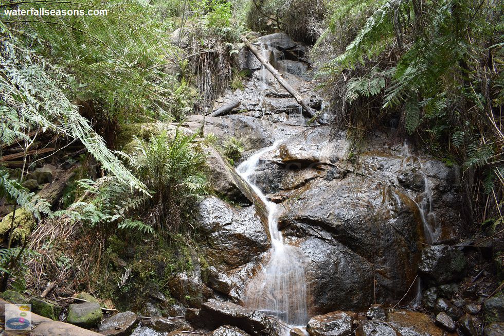
 Above: The La La Falls cascade in Warburton
(Order this image)
The falls themselves are a single set of cascades rather than falls, with the water in the creek splashing down and bouncing around from one exposed boulder to the next. Relax on the wooden bench at the base and let yourself be mesmerised by the rushing water.
The walk to the falls is a gradual ascent of 1.6 km (each way) on a reasonably wide track. The forest walk is enjoyable in its own right, with the falls providing the icing on the cake at the end of the trail.
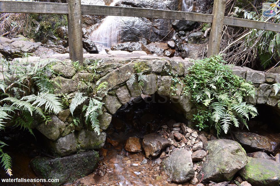
Apart from the scenery and bird life in the forest, another unique feature of this walk are the stone arch bridges along the way. There are several of them, with the
last one allowing you to cross the creek below the falls. The forest has grown into the stones, which look like they could easily house little
trolls or other such magical creatures. From an engineering point of view, they have been expertly constructed by skilled stonemasons, with the bridges still standing after
such a long time. Given how low they are, I would imagine they would be easily overtopped during minor floods.
 Above: A stone arch bridge at La La Falls, Warburton
(Order this image)
The last section of road to the falls is unsealed, but suitable for 2WD vehicles under most weather conditions. There are only a few parking spaces beside the road at the start of the walk, and only a single picnic table beside the road, so it is probably best to head down to Warburton for lunch before or after your visit to these falls, rather than trying to have a picnic at the falls.
Lastly, don't forget to bring some insect repellent, as there were some mozzies buzzing around at the falls on my visit.
Here is a video of the falls, taken in the early afternoon in October, when the creek was flowing after a few millimetres of rain earlier in the week, but was not in flood. The video includes some walking track notes:
View Larger Map
 Above: The La La Falls cascade in Warburton
(Order this image)
The falls themselves are a single set of cascades rather than falls, with the water in the creek splashing down and bouncing around from one exposed boulder to the next. Relax on the wooden bench at the base and let yourself be mesmerised by the rushing water.
The walk to the falls is a gradual ascent of 1.6 km (each way) on a reasonably wide track. The forest walk is enjoyable in its own right, with the falls providing the icing on the cake at the end of the trail.
 Above: A stone arch bridge at La La Falls, Warburton
(Order this image)
The last section of road to the falls is unsealed, but suitable for 2WD vehicles under most weather conditions. There are only a few parking spaces beside the road at the start of the walk, and only a single picnic table beside the road, so it is probably best to head down to Warburton for lunch before or after your visit to these falls, rather than trying to have a picnic at the falls.
Here is a video of the falls, taken in the early afternoon in October, when the creek was flowing after a few millimetres of rain earlier in the week, but was not in flood. The video includes some walking track notes:
Your Seasonal Guide:
| Best Time of Year to Visit: | Best Time of Day to Visit: |
|---|---|
| The highest flows typically occur in winter and spring. There is no flow data at this site, but the nearest similar catchment suggest the falls will still have a trickle in most summers. | Visit in the afternoon when the sun will better penetrate through the gap in the canopy to illuminate the falls |
Other Information Before You Go:
Location: Yarra State Forest, Irruka Road, Warburton, 80 km (approx. 90 minute drive) east of the Melbourne CBD.
Latitude:-37.765562 Longitude:145.701683
Getting there: From Melbourne head along the Maroondah Hwy (route 34) and then the Warburton Hwy (route B380) to Warburton. From Warbuton, follow the signs to the falls via Park Road, then La La Ave and Old Warburton Road to Irruka Road. The falls are a further 1.6 km by foot from the roadside parking on Irruka Road.
Water source: Four Mile Creek
Approx. height: 10 metres
Approx. width: 2-3 metres
Approx. length: 5 metres
Swimming available at the falls: No, but you can dip the soles of your feet in the water.
Facilities: Roadside parking for a handful of cars, and a single picnic table next to the road. No facilities at the falls except for a single bench seat. Take your rubbish home with you.
Entrance fee: None
Opening times: Always open
Sun shade: Shade available at the falls and along most of the walking track
Wheelchair access: There is no wheelchair access to the falls
Prohibitions including whether you can bring your dog: No prohibitions specified on site at the time of my visit. Within the Yarra State Forest, dogs are permitted but must be kept under direct control at all times and on a leash when near other visitors. Do not disturb native plants or animals.
Managing authority: Victorian Department of Environment, Land, Water and Planning
Nearby attractions: Stop off at Seville Water Play on the way up to Warburton.
Before you head out, make sure you read the
waterfall safety information and check with the managing authority for any current change of conditions.
Specific to this site, bring some insect repellent for the mosquitos.
Latitude:-37.765562 Longitude:145.701683
Getting there: From Melbourne head along the Maroondah Hwy (route 34) and then the Warburton Hwy (route B380) to Warburton. From Warbuton, follow the signs to the falls via Park Road, then La La Ave and Old Warburton Road to Irruka Road. The falls are a further 1.6 km by foot from the roadside parking on Irruka Road.
Water source: Four Mile Creek
Approx. height: 10 metres
Approx. width: 2-3 metres
Approx. length: 5 metres
Swimming available at the falls: No, but you can dip the soles of your feet in the water.
Facilities: Roadside parking for a handful of cars, and a single picnic table next to the road. No facilities at the falls except for a single bench seat. Take your rubbish home with you.
Entrance fee: None
Opening times: Always open
Sun shade: Shade available at the falls and along most of the walking track
Wheelchair access: There is no wheelchair access to the falls
Prohibitions including whether you can bring your dog: No prohibitions specified on site at the time of my visit. Within the Yarra State Forest, dogs are permitted but must be kept under direct control at all times and on a leash when near other visitors. Do not disturb native plants or animals.
Managing authority: Victorian Department of Environment, Land, Water and Planning
Nearby attractions: Stop off at Seville Water Play on the way up to Warburton.
Locality Map:
The marker indicates the approximate location of the roadside parking where the walk to the falls starts. If the map is not zoomed in locally, as can occur with some browsers, simply refresh this web page.
View Larger Map
Comments:
If you would like to leave a comment about this waterfall, please fill in the comment box below.
I'm particularly interested in your experiences after visiting, and any changes in conditions, etc.
All fields are required if you would like to see your comments appear on this website.
| ← Back | Next Falls → |
| Victoria | Melbourne |
| Safety Info | Map |
| List of Lists | Your Support |
| Feedback | Media |
|
|
|
|
|
|
|
|
|
|
© Brad Neal 2024. All rights reserved. Here are my
affiliate links and cookies policy and opportunities to provide support to Waterfall Seasons.