| ← Back | Next Falls → |
Narracan Falls, Narracan VICWaterfall Seasons - The Waterfall Guide
| Australia |
| Victoria |
| Regions of Victoria: |
| Melbourne |
| Nth East VIC |
| Western VIC |
| Gippsland |
| Other Information: |
| Safety Info |
| Map |
| Your Support |
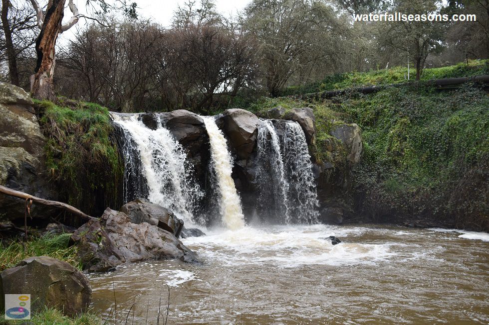
In winter and spring you can hear the roar of Narracan Falls before you have even stepped out of your car.
With a steady flow of water that continues even through summer, Narracan Falls is a fairly reliable waterfall and picnic spot, easily
accessible from the Latrobe Valley.
 Above: Narracan Falls from below in winter
(Order this image)
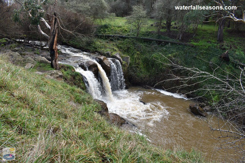
There is good access to the falls, with a grassy paddock running alongside the creek that provides a clear, elevated view of the falls. The top of the falls can be explored up close, particulary during summer and autumn when it is easier to rock hop over parts of the creek to the little islands mid-stream.
Downstream an easily traversed dirt walking track winds down the gully wall to the base of the falls and the muddy pool.
 Above: Narracan Falls from the picnic area in winter
(Order this image)
There are two picnic tables spread far apart and a couple of fire pits that could make for a fun day out. How fun it is probably depends on your attitude towards livestock, as the paddock is sometimes shared with an local herd of adorable cows.
If you are playing games in the paddock, watch
out for the little treasures that the cows have left behind in the grass, even if they are not around at the time of your visit.
There is also a walking track that runs along the creek downstream. I have not walked along this track, and it is not marked on the maps on site, but on my visit there was someone who took off along the track with a small back pack and did not come back for the whole time I was there, so it must be of reasonable length.
Here is a video of the falls, taken in early winter, when the creek was flowing well, but not in flood:
View Larger Map
 Above: Narracan Falls from below in winter
(Order this image)
There is good access to the falls, with a grassy paddock running alongside the creek that provides a clear, elevated view of the falls. The top of the falls can be explored up close, particulary during summer and autumn when it is easier to rock hop over parts of the creek to the little islands mid-stream.
 Above: Narracan Falls from the picnic area in winter
(Order this image)
There are two picnic tables spread far apart and a couple of fire pits that could make for a fun day out. How fun it is probably depends on your attitude towards livestock, as the paddock is sometimes shared with an local herd of adorable cows.
There is also a walking track that runs along the creek downstream. I have not walked along this track, and it is not marked on the maps on site, but on my visit there was someone who took off along the track with a small back pack and did not come back for the whole time I was there, so it must be of reasonable length.
Here is a video of the falls, taken in early winter, when the creek was flowing well, but not in flood:
Your Seasonal Guide:
| Best Time of Year to Visit: | Best Time of Day to Visit: |
|---|---|
| With reliable flow all year round, even in drought years, anytime is good to visit | Visit in the morning to see the falls in full sun, or at dusk to see the sun set behind the falls |
Other Information Before You Go:
Location: Narracan Falls Reserve, 275 Falls Road, Narracan, 15 km south of Moe or 140 km (approx. 2 hr drive) east of the Melbourne CBD.
Latitude:-38.269084 Longitude:146.216172
Getting there: From Melbourne head along the Monash Fwy (M1) to Trafalgar. In Trafalgar, head south into Ashby Street which becomes the Mirboo North - Trafalgar Road (C469). After approximately 8 km, turn east along the Narracan Connection Road for 3 km, then south along Falls Road for 1.4 km. The car park for Narracan Falls Reserve is beside the road. It is easy to get disorientated in these rolling hills, even if following the road signs to the falls, so a map or GPS will definitely help.
Water source: Narracan Creek
Approx. height: 8 metres
Approx. width: 15 metres
Approx. length: Vertical drop
Swimming available at the falls: The managing authority states that swimming is not advised. There is a pool at the base of the falls but visibility is poor and there are submerged rocks.
Facilities: Picnic tables, fire pits, grassy paddock, car park. There are no bins, so take your rubbish home with you.
Entrance fee: None
Opening times: Always open
Sun shade: Areas of shade are available near the edge of the creek gully. Limited to no shade at the picnic tables.
Wheelchair access: There is no formal wheelchair access to the falls. In dry conditions, it may be possible to view the falls from the paddock. The gate into the paddock is narrow, and the ground is uneven and can have cowpats.
Prohibitions including whether you can bring your dog: Fires must be extinguished before leaving. Dogs permitted.
Managing authority: Baw Baw Shire Council
Nearby attractions: If you want to see where Narracan Creek ends up, head to Lake Narracan at the back of Moe, around 15 km to the north.
Before you head out, make sure you read the
waterfall safety information and check with the managing authority for any current change of conditions.
Specific to this site, the managing authority advises that there are snakes, steep cliffs, submerged obstacles, slippery rocks, and that livestock
may have access to your picnic area.
Latitude:-38.269084 Longitude:146.216172
Getting there: From Melbourne head along the Monash Fwy (M1) to Trafalgar. In Trafalgar, head south into Ashby Street which becomes the Mirboo North - Trafalgar Road (C469). After approximately 8 km, turn east along the Narracan Connection Road for 3 km, then south along Falls Road for 1.4 km. The car park for Narracan Falls Reserve is beside the road. It is easy to get disorientated in these rolling hills, even if following the road signs to the falls, so a map or GPS will definitely help.
Water source: Narracan Creek
Approx. height: 8 metres
Approx. width: 15 metres
Approx. length: Vertical drop
Swimming available at the falls: The managing authority states that swimming is not advised. There is a pool at the base of the falls but visibility is poor and there are submerged rocks.
Facilities: Picnic tables, fire pits, grassy paddock, car park. There are no bins, so take your rubbish home with you.
Entrance fee: None
Opening times: Always open
Sun shade: Areas of shade are available near the edge of the creek gully. Limited to no shade at the picnic tables.
Wheelchair access: There is no formal wheelchair access to the falls. In dry conditions, it may be possible to view the falls from the paddock. The gate into the paddock is narrow, and the ground is uneven and can have cowpats.
Prohibitions including whether you can bring your dog: Fires must be extinguished before leaving. Dogs permitted.
Managing authority: Baw Baw Shire Council
Nearby attractions: If you want to see where Narracan Creek ends up, head to Lake Narracan at the back of Moe, around 15 km to the north.
Locality Map:
The marker indicates the approximate location of the car park at the falls. If the map is not zoomed in locally, as can occur with some browsers, simply refresh this web page.
View Larger Map
Comments:
If you would like to leave a comment about this waterfall, please fill in the comment box below.
I'm particularly interested in your experiences after visiting, and any changes in conditions, etc.
All fields are required if you would like to see your comments appear on this website.
| ← Back | Next Falls → |
| Victoria | Gippsland |
| Safety Info | Map |
| List of Lists | Your Support |
| Feedback | Media |
|
|
|
|
|
|
|
|
|
|
© Brad Neal 2024. All rights reserved. Here are my
affiliate links and cookies policy and opportunities to provide support to Waterfall Seasons.