| ← Back | Next Falls → |
Sherbrooke Falls, Melbourne, VICWaterfall Seasons - The Waterfall Guide
| Australia |
| Victoria |
| Regions of Victoria: |
| Melbourne |
| Nth East VIC |
| Western VIC |
| Gippsland |
| Other Information: |
| Safety Info |
| Map |
| Your Support |
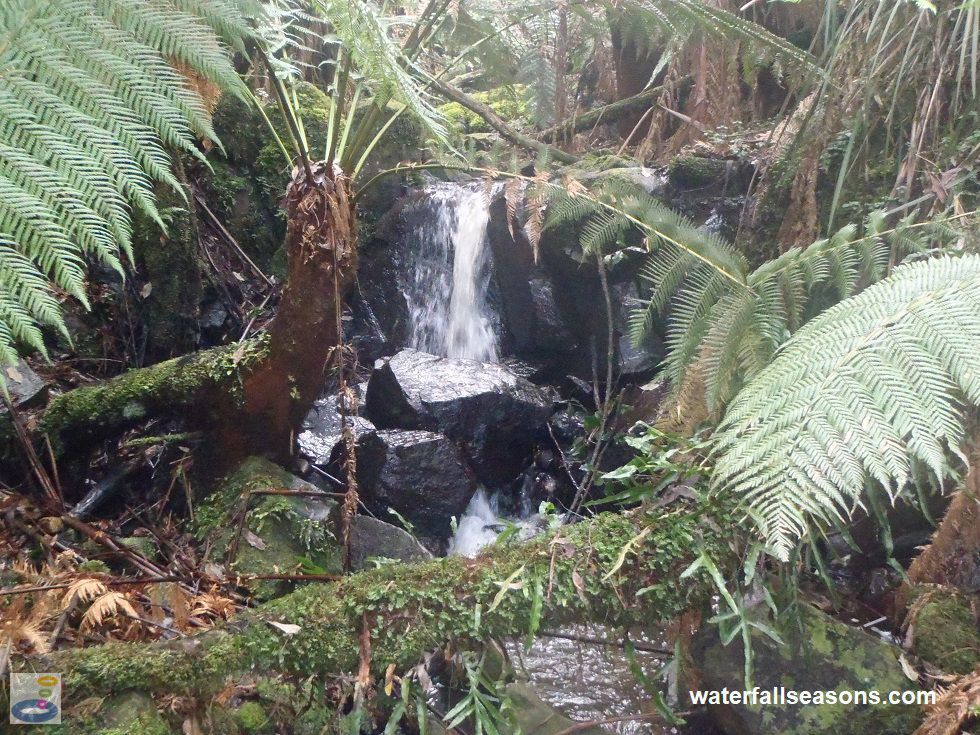
Sherbrooke Falls is a bit like Stonehenge in that all of the photos, including mine, make it seem larger than it really is. At less than a metre across
and a couple of metres high, the falls are tiny. To view them from the platform that crosses the creek, you have to peer up the creek
where you will find the falls hidden in amongst the tree ferns. The falls are south-east facing in a thick forest, so not a lot of light reaches
through to them.
 Above: Sherbrooke Falls
(Order this image)
The best time to visit is early in the morning around the summer solstice, when light penetrates better through to the falls.
The falls are in a section of the creek with a very steep gradient containing several small cascades downstream of the viewing platform, however it is difficult
to view these cascades from the defined walking tracks.
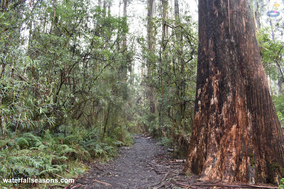
 Above: The walk through Sherbrooke Forest to Sherbrooke Falls
(Order this image)
The star attraction at Sherbrooke Falls I think is actually the surrounding forest, and the falls are really just somewhere to walk to. The stands of mountain ash are incredibly tall and straight, and it is dizzying trying to look up at them.
It is amazing how well trees can grow in good soil with
lots of rain - I saw a wattle tree in bloom on the way to the falls that must have been about 20 metres high. Tall tree ferns abound in the under storey
and the air is crisp and fresh.
You can walk to the falls from several directions, but the easiest is from either O'Donahue or Sherbrooke Picnic Ground. The track from Sherbrooke Picnic Ground is slightly longer but a bit flatter. O'Donahue Picnic Ground has the better picnic area if you are making a day of it.
Here is a video of the falls and surrounding forest, taken in the morning in winter, when the creek was flowing well, but not in flood. It includes some of the wildlife in the surrounding forest:
View Larger Map
 Above: Sherbrooke Falls
(Order this image)
The best time to visit is early in the morning around the summer solstice, when light penetrates better through to the falls.
 Above: The walk through Sherbrooke Forest to Sherbrooke Falls
(Order this image)
The star attraction at Sherbrooke Falls I think is actually the surrounding forest, and the falls are really just somewhere to walk to. The stands of mountain ash are incredibly tall and straight, and it is dizzying trying to look up at them.
You can walk to the falls from several directions, but the easiest is from either O'Donahue or Sherbrooke Picnic Ground. The track from Sherbrooke Picnic Ground is slightly longer but a bit flatter. O'Donahue Picnic Ground has the better picnic area if you are making a day of it.
Here is a video of the falls and surrounding forest, taken in the morning in winter, when the creek was flowing well, but not in flood. It includes some of the wildlife in the surrounding forest:
Your Seasonal Guide:
| Best Time of Year to Visit: | Best Time of Day to Visit: |
|---|---|
| Reliable flow all year except during summer/autumn in drought years | Early morning for your best chance to see sunshine penetrate through the forest canopy onto the falls |
Other Information Before You Go:
Location: O'Donahue Picnic Ground, Sherbrooke Road, Sherbrooke. 45 km (approx. 1 hr drive) east of the Melbourne CBD.
Latitude:-37.883607 Longitude:145.357615
Getting there: From Melbourne head to the Mount Dandenong Tourist Rd via the Monash Fwy to Ferntree Gully Rd. The Sherbrooke Rd turnoff is shortly after the village of Ferny Creek on the way up the mountain. From Sherbrooke Rd, turn into Sherbrooke Lodge Rd to reach O'Donahue Picnic Ground. The falls are a 2.4 km return walk from the picnic ground.
Water source: Sherbrooke Creek
Approx. height: 2 m Approx. width: 1 m
Approx. length: Vertical drop
Swimming available at the falls: No
Facilities: None at the falls. O'Donahue Picnic Ground and Sherbrooke Picnic Ground both have bbqs, picnic tables, a tap, toilets and an info board
Entrance fee: None
Opening times: Always open
Sun shade: Shade available at the picnic grounds, on the walk to the falls and at the falls
Wheelchair access: None to the falls. Picnic grounds have wheelchair accessible toilets.
Prohibitions: No cats or dogs, no trail bikes, no horses, no bicycles, no feeding the wildlife, no bins so take your rubbish with you
Managing authority: Parks Victoria
Nearby attractions: Hungry cockatoos at Grants Picnic Ground in nearby Kallista, and Olinda Falls, also in the Dandenongs, 11 km by road to the north.
Before you head out, make sure to read the
waterfall safety information and check with the managing authority for any current change of conditions.
Latitude:-37.883607 Longitude:145.357615
Getting there: From Melbourne head to the Mount Dandenong Tourist Rd via the Monash Fwy to Ferntree Gully Rd. The Sherbrooke Rd turnoff is shortly after the village of Ferny Creek on the way up the mountain. From Sherbrooke Rd, turn into Sherbrooke Lodge Rd to reach O'Donahue Picnic Ground. The falls are a 2.4 km return walk from the picnic ground.
Water source: Sherbrooke Creek
Approx. height: 2 m Approx. width: 1 m
Approx. length: Vertical drop
Swimming available at the falls: No
Facilities: None at the falls. O'Donahue Picnic Ground and Sherbrooke Picnic Ground both have bbqs, picnic tables, a tap, toilets and an info board
Entrance fee: None
Opening times: Always open
Sun shade: Shade available at the picnic grounds, on the walk to the falls and at the falls
Wheelchair access: None to the falls. Picnic grounds have wheelchair accessible toilets.
Prohibitions: No cats or dogs, no trail bikes, no horses, no bicycles, no feeding the wildlife, no bins so take your rubbish with you
Managing authority: Parks Victoria
Nearby attractions: Hungry cockatoos at Grants Picnic Ground in nearby Kallista, and Olinda Falls, also in the Dandenongs, 11 km by road to the north.
Locality Map:
The marker indicates the approximate location of the falls. The car park at O'Donahue Picnic Ground, at the start of one of the walking tracks to the falls, is 800 metres
north-east of the falls. If the map is not zoomed in locally, as can occur with some browsers, simply refresh this web page.
View Larger Map
Comments:
If you would like to leave a comment about this waterfall, please fill in the comment box below.
I'm particularly interested in your experiences after visiting, and any changes in conditions, etc.
All fields are required if you would like to see your comments appear on this website.
| ← Back | Next Falls → |
| Victoria | Melbourne |
| Safety Info | Map |
| List of Lists | Your Support |
| Feedback | Media |
|
|
|
|
|
|
|
|
|
|
© Brad Neal 2024. All rights reserved. Here are my
affiliate links and cookies policy and opportunities to provide support to Waterfall Seasons.