| ← Back | Next Falls → |
Whian Whian Falls, Whian Whian, NSWWaterfall Seasons - The Waterfall Guide
Flow over these rocky, multifaceted falls in the aptly named Rocky Creek is somewhat dependent on whether Rocky Creek Dam is spilling, 8 km upstream. If the water level is low enough, as it was on my visit,
and if you don't mind getting your feet wet, wade across to the opposite side of the creek and take up a front row seat on the large dry rock bars located in amongst the falls.
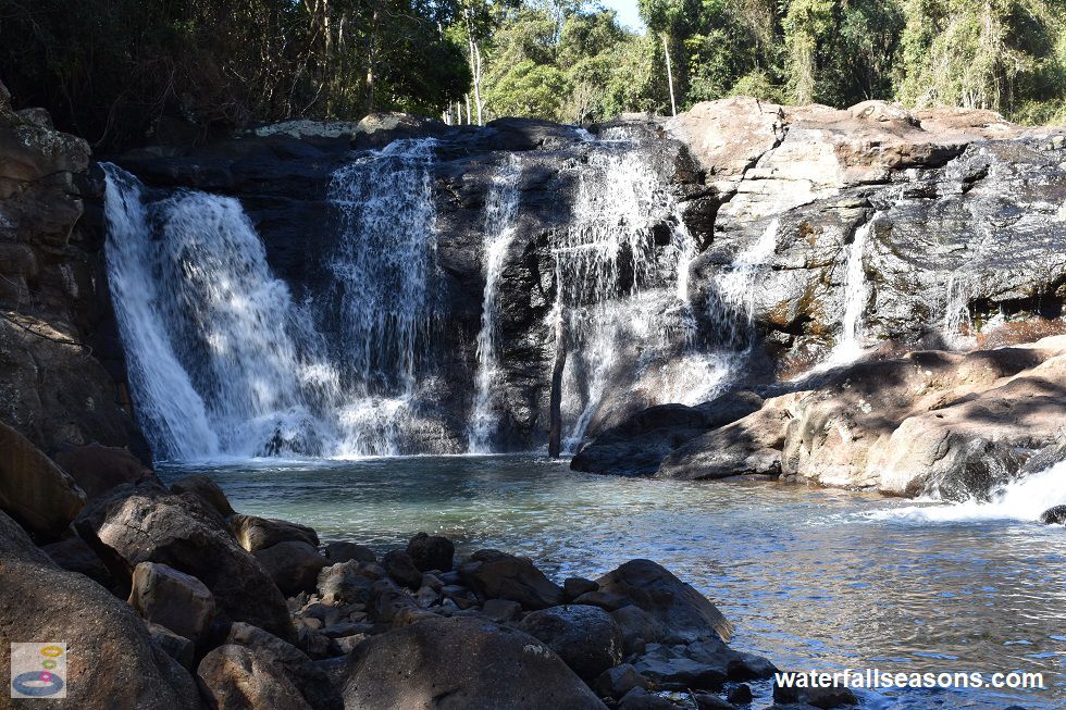
 Above: Whian Whian Falls from the base of the falls
(Order this image)
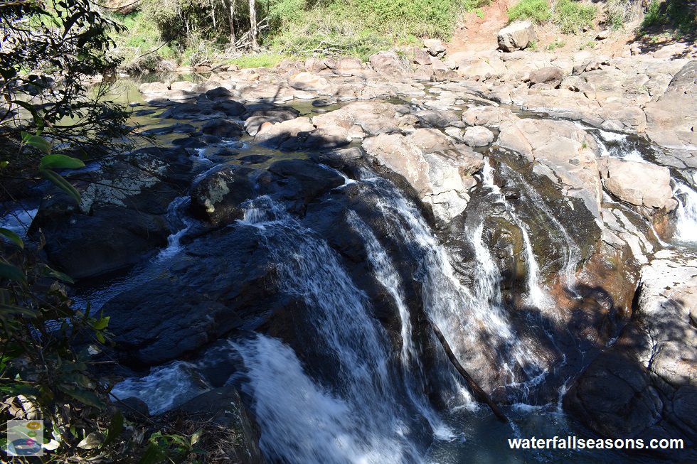
The main flow path over the falls is on the northern bank, where there is a near vertical drop of around 5 metres into a small but deep pool below. I describe these falls as multifaceted because beside this main flow path, the falls split into several side branches that spill down into a little rock channel, which then spills back into the main pool through two rock chutes.
The water heads in different directions at different angles, taking either the fast or slow route to the creek downstream.
 Above: The rocky stream above Whian Whian Falls splitting in different directions
(Order this image)
Whilst the walk to the falls is short (~150 metres), the last section of the path down to the falls is quite narrow and steep, with a sheer drop down into the gully on one side and nothing stable to hang onto.
This section could be difficult for elderly visitors or young children, who can still however view the falls in their entirety from above, without
having to traverse this section of track.
There are no facilities here, but on my visit there were two friends who had carefully carried their small picnic hamper across the creek and were enjoying a picnic on the rocks next to the waterfall, which looked like a pretty good plan for the afternoon here.
Here is a quick video of the falls taken on a dry day in winter when Rocky Creek was flowing mildly, but not in flood, and Rocky Creek Dam was full. It includes some track notes and a panorama from the rock bar beneath and beside the falls. The video is a bit limited because I wanted to avoid filming the picnickers, but hopefully still gives you a sense of what to expect.
View Larger Map
 Above: Whian Whian Falls from the base of the falls
(Order this image)
The main flow path over the falls is on the northern bank, where there is a near vertical drop of around 5 metres into a small but deep pool below. I describe these falls as multifaceted because beside this main flow path, the falls split into several side branches that spill down into a little rock channel, which then spills back into the main pool through two rock chutes.
 Above: The rocky stream above Whian Whian Falls splitting in different directions
(Order this image)
Whilst the walk to the falls is short (~150 metres), the last section of the path down to the falls is quite narrow and steep, with a sheer drop down into the gully on one side and nothing stable to hang onto.
There are no facilities here, but on my visit there were two friends who had carefully carried their small picnic hamper across the creek and were enjoying a picnic on the rocks next to the waterfall, which looked like a pretty good plan for the afternoon here.
Here is a quick video of the falls taken on a dry day in winter when Rocky Creek was flowing mildly, but not in flood, and Rocky Creek Dam was full. It includes some track notes and a panorama from the rock bar beneath and beside the falls. The video is a bit limited because I wanted to avoid filming the picnickers, but hopefully still gives you a sense of what to expect.
Your Seasonal Guide:
| Best Time of Year to Visit: | Best Time of Day to Visit: |
|---|---|
| Flows over the falls are heavily dependent on whether Rocky Creek Dam, 8 km upstream, is spilling. There are no minimum passing flows at the dam. Historically, the upstream dam was most likely to be spilling in March and April, and least likely to be spilling from September through to February. | Visit from midday to mid-afternoon to see the most sunlight on the falls |
Other Information Before You Go:
Location: 111 Whian Whian Road, Whian Whian, 21 km (approx. 25 min drive) north of Lismore and 750 km (approx. 8 hr drive) north of the Sydney CBD.
Latitude:-28.662709 Longitude:153.319668
Getting there: From the western edge of Lismore, follow Dunoon Road (Tweed St) north for 18 km, past Dunoon. Head west at Whian Whian Road and follow it for 1.1 km until you reach the roadside parking area on the western side of Rocky Creek. From the parking area, follow the track that runs alongside the road, leading back down to the creek, before turning right to head downstream. It is about a 150 metre walk along this track down to the falls. Do not take the track from the parking area that heads straight into the forest, as it is more difficult to reach the falls via this track.
Water source: Rocky Creek
Approx. height: 5 metres
Approx. width: 10-15 metres
Approx. length: 2 metres
Swimming available at the falls: Yes
Facilities: A handful of car parking spaces
Entrance fee: None
Opening times: Always open
Sun shade: Shade available at the car park area and on the bank next to the falls. Limited to no shade over parts of the falls including the rock bars in the middle of the creek.
Wheelchair access: None
Prohibitions: No motorbikes, no dogs, no alcohol, no fires, no camping.
Accommodation Options: See my accommodation suggestions close to Whian Whian Falls.
Managing authority: Rous County Council
Nearby attractions: Bexhill Quarry, 17 km to the south. Bring some loose change for the various produce available in roadside stalls in this area, including (seasonally variable) avocados, tomatoes and macadamias.
Before you head out, make sure to read the
waterfall safety information and check with the managing authority for any current change of conditions. Specific to this waterfall, the managing authority advises of
cliff edges, falling branches, slippery surface, water, and uneven ground. The managing authority advises that people "Enter at your own risk. Accessing this area is a high risk activity. Be aware of
natural hazards and weather conditions. Great care should be taken as conditions can change quickly".
Latitude:-28.662709 Longitude:153.319668
Getting there: From the western edge of Lismore, follow Dunoon Road (Tweed St) north for 18 km, past Dunoon. Head west at Whian Whian Road and follow it for 1.1 km until you reach the roadside parking area on the western side of Rocky Creek. From the parking area, follow the track that runs alongside the road, leading back down to the creek, before turning right to head downstream. It is about a 150 metre walk along this track down to the falls. Do not take the track from the parking area that heads straight into the forest, as it is more difficult to reach the falls via this track.
Water source: Rocky Creek
Approx. height: 5 metres
Approx. width: 10-15 metres
Approx. length: 2 metres
Swimming available at the falls: Yes
Facilities: A handful of car parking spaces
Entrance fee: None
Opening times: Always open
Sun shade: Shade available at the car park area and on the bank next to the falls. Limited to no shade over parts of the falls including the rock bars in the middle of the creek.
Wheelchair access: None
Prohibitions: No motorbikes, no dogs, no alcohol, no fires, no camping.
Accommodation Options: See my accommodation suggestions close to Whian Whian Falls.
Managing authority: Rous County Council
Nearby attractions: Bexhill Quarry, 17 km to the south. Bring some loose change for the various produce available in roadside stalls in this area, including (seasonally variable) avocados, tomatoes and macadamias.
Locality Map:
The marker indicates the approximate location of the car parking area at the start of the walk to the falls. If the map is not zoomed in locally, as can sometimes occur when loading, simply click or tap on "View Larger Map" below.
View Larger Map
Comments:
If you would like to leave a comment about this waterfall, please fill in the comment box below.
I'm particularly interested in your experiences after visiting, and any changes in conditions, etc.
All fields are required if you would like to see your comments on this website.
| ← Back | Next Falls → |
| Australia | NSW / ACT |
| Safety Info | Map |
| List of Lists | Your Support |
| Feedback | Media |
|
|
|
|
|
|
|
|
|
|
© Brad Neal 2024. All rights reserved. Here are my
affiliate links and cookies policy and opportunities to provide support to Waterfall Seasons.