| ← Back | Next Falls → |
Buley Rockhole, Litchfield NP, NTWaterfall Seasons - The Waterfall Guide
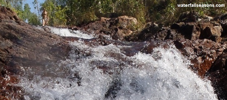
Buley Rockhole is a series of cascades interspersed with flat rock shelves over a length of around 30 metres. There are actually several rockholes within the rock
shelves and most are surprisingly deep (> 2 metres).
 Above: Buley Rockhole
(Order this image)
The rock can be slippery. I suggest you keep your centre of gravity low with crab like movements as you wander across the rock to avoid a dangerous fall. You can scramble, jump or swim the full length of the rockholes from top to bottom, or use the dirt path beside the river.
You can view the cascades from either bank, and from either upstream or downstream of the cascades.
It is difficult to photograph the length of the cascades because there are no well elevated viewpoints.
Car parking at Buley Rockhole is in short supply, so you might need to do a few loops to get a spot at peak times. If that is the case, you can always go to Florence Falls and walk to Buley Rockhole by following the walking track along the river from there. There are always people at the rockhole because of the campground on site and the regular busloads of tourists coming in from Darwin. If you want to avoid the buses, visit the rockhole early or late in the day and go to other less popular falls nearby during the middle of the day.
After photography, the most popular activity here is jumping into the deeper holes during the dry season. Bring a waterproof camera and a snorkel to explore the pools. It is always hot here, so wading in the water will be a welcome relief.
View Larger Map
 Above: Buley Rockhole
(Order this image)
The rock can be slippery. I suggest you keep your centre of gravity low with crab like movements as you wander across the rock to avoid a dangerous fall. You can scramble, jump or swim the full length of the rockholes from top to bottom, or use the dirt path beside the river.
Car parking at Buley Rockhole is in short supply, so you might need to do a few loops to get a spot at peak times. If that is the case, you can always go to Florence Falls and walk to Buley Rockhole by following the walking track along the river from there. There are always people at the rockhole because of the campground on site and the regular busloads of tourists coming in from Darwin. If you want to avoid the buses, visit the rockhole early or late in the day and go to other less popular falls nearby during the middle of the day.
After photography, the most popular activity here is jumping into the deeper holes during the dry season. Bring a waterproof camera and a snorkel to explore the pools. It is always hot here, so wading in the water will be a welcome relief.
Your Seasonal Guide:
| Best Time of Year to Visit: | Best Time of Day to Visit: |
|---|---|
| Visit in the dry season (approx. May-Oct) when crocs are removed from the area. The rockholes are spring fed and are not known to dry up. | Visit either in the morning or the afternoon to avoid the tourist buses in the middle of the day. |
Other Information Before You Go:
Location: Litchfield National Park, 140 km (approx. 2 hour 20 minute drive) south-west of the Darwin city centre
Latitude:-13.113218 Longitude:130.785633
Getting there: From Darwin take the Stuart Hwy southwards and turn off at the signs to Litchfield National Park (via Batchelor). The turnoff to Buley Rockhole is well signposted.
Water source: Florence Creek
Approx. height: 15 m
Approx. width: 5 m
Approx. length: 20 m
Swimming available at the falls: Yes
Facilities: Toilets, campground, car park
Entrance fee: Not applicable
Opening times: Always open
Managing authority: NT Parks and Wildlife Service
Nearby attractions: Florence Falls is around the corner
Before you head out, make sure to read the
waterfall safety information and check with the managing authority for any current change of conditions.
Specific to Litchfield National Park, the managing authority warns of the presence of scrub typhus, which is caused by bites from a mite.
Precautions include wearing enclosed footwear, long trousers, insect repellent, camping away from dense forests, and using a
ground sheet when sitting or laying on the ground.
Latitude:-13.113218 Longitude:130.785633
Getting there: From Darwin take the Stuart Hwy southwards and turn off at the signs to Litchfield National Park (via Batchelor). The turnoff to Buley Rockhole is well signposted.
Water source: Florence Creek
Approx. height: 15 m
Approx. width: 5 m
Approx. length: 20 m
Swimming available at the falls: Yes
Facilities: Toilets, campground, car park
Entrance fee: Not applicable
Opening times: Always open
Managing authority: NT Parks and Wildlife Service
Nearby attractions: Florence Falls is around the corner
Locality Map:
The marker indicates the approximate location of the car park near the rockhole. If the map is not zoomed in locally, as can occur with some browsers, simply refresh this web page.
View Larger Map
Comments:
If you would like to leave a comment about this waterfall, please fill in the comment box below.
I'm particularly interested in your experiences after visiting, and any changes in conditions, etc.
All fields are required if you would like to see your comments on this website.
| ← Back | Next Falls → |
| Australia | Northern Territory |
| Safety Info | Map |
| List of Lists | Your Support |
| Feedback | Media |
|
|
|
|
|
|
|
|
|
|
© Brad Neal 2024. All rights reserved. Here are my
affiliate links and cookies policy and opportunities to provide support to Waterfall Seasons.