| ← Back | Next Falls → |
Kings Falls, Arthurs SeatWaterfall Seasons - The Waterfall Guide
| Australia |
| Victoria |
| Regions of Victoria: |
| Melbourne |
| Nth East VIC |
| Western VIC |
| Gippsland |
| Other Information: |
| Safety Info |
| Map |
| Your Support |
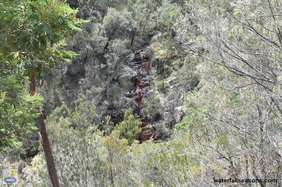
These falls on Melbourne's Mornington Peninsula are best viewed immediately after rainfall, as you will struggle to catch glimpses of the water at other times.
The viewing areas are orientated such that it is difficult to get a clear view of the water unless there has been steady or heavy rain, when water gushes down over the exposed rock.
I have visited during both wet and dry conditions.
 Above: View of Kings Falls across the valley at roughly two to three times magnification
(Order this image)
There are a few different ways to walk to the falls, but I took the shortest route, which is the 1 km circuit walk from the roadside parking area on Waterfall Gully Road. Along the walk there are two viewing areas for the falls.
Taking the circuit walk in a clockwise direction, as recommended by the directional arrows on the signs
at the car park, the first viewing area is a portrait view of the falls from across the valley.
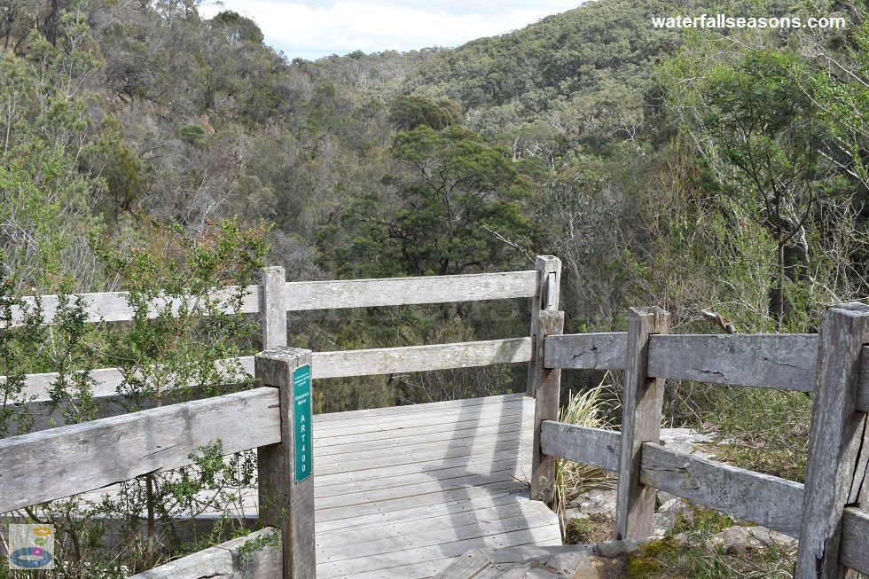
It is the best view of the falls in their entirety, but from around 150-200 metres away, so bring your binoculars to see any of the waterfall detail. The main viewing platform is a few hundred metres further along, and is perched adjacent to the falls on the edge of the valley. The profile view of the falls here is still at a distance of around 10-20 metres from the water, and partly obscured by vegetation, so you won't see much unless the water is really rushing through. The elevated views from the platform down to the valley floor below are still worth a look, even if the creek is not flowing. Above: The viewing platform at Kings Falls
(Order this image)
After viewing the falls, continue on the circuit walk further upstream where you can study the creek up close at one of the creek crossings. The walk has boardwalks across all of the damp gullies to keep your feet dry. I have seen a lot of active bird life on my visits, including different types of wagtails and wrens, plus wildflowers in bloom alongside the track.
There are no picnic facilities at the falls, so head up to the picturesque Seawinds Gardens in Arthurs Seat (on Purves Road) after your walk for a picnic. For the energetic,
you can also walk roughly 3 km along the Two Bays Walking Track from Seawinds Gardens down to the falls.
Here is a video of the falls, taken in both wet and dry conditions so you can see the contrast and pick a time to visit that appeals to you:
View Larger Map
 Above: View of Kings Falls across the valley at roughly two to three times magnification
(Order this image)
There are a few different ways to walk to the falls, but I took the shortest route, which is the 1 km circuit walk from the roadside parking area on Waterfall Gully Road. Along the walk there are two viewing areas for the falls.
It is the best view of the falls in their entirety, but from around 150-200 metres away, so bring your binoculars to see any of the waterfall detail. The main viewing platform is a few hundred metres further along, and is perched adjacent to the falls on the edge of the valley. The profile view of the falls here is still at a distance of around 10-20 metres from the water, and partly obscured by vegetation, so you won't see much unless the water is really rushing through. The elevated views from the platform down to the valley floor below are still worth a look, even if the creek is not flowing.
 Above: The viewing platform at Kings Falls
(Order this image)
After viewing the falls, continue on the circuit walk further upstream where you can study the creek up close at one of the creek crossings. The walk has boardwalks across all of the damp gullies to keep your feet dry. I have seen a lot of active bird life on my visits, including different types of wagtails and wrens, plus wildflowers in bloom alongside the track.
Here is a video of the falls, taken in both wet and dry conditions so you can see the contrast and pick a time to visit that appeals to you:
Your Seasonal Guide:
| Best Time of Year to Visit: | Best Time of Day to Visit: |
|---|---|
| Visit immediately after rainfall to see the falls flowing well. The creek will be dry if it has not rained recently. | Visit in the afternoon when the sun will better illuminate the falls, with colours changing close to dusk |
Other Information Before You Go:
Location: Arthurs Seat State Park, Waterfall Gully Road, Main Ridge, 90 km (approx. 90 minute to 2 hr drive) south of the Melbourne CBD. Waterfall Gully Road is right on
the border of Rosebud, Main Ridge and Arthurs Seat, so try these other area names if your GPS does not recognise the road as being in Main Ridge.
Latitude:-38.373122 Longitude:144.944453
Getting there: From Melbourne head along Peninsula Link (aka Mornington Peninsula Fwy, route M11) to Arthurs Seat. After ascending the windy road to Arthurs Seat, head down Purves Road to Waterfall Gully Road. The roadside parking is 1 km from Purves Road. The falls are a further 500 metres by foot from the roadside parking area.
Water source: Waterfall Creek
Approx. height: Difficult to judge, but probably in the order of 20-30 metres
Approx. width: 1-3 metres
Approx. length: 10-20 metres
Swimming available at the falls: No
Facilities: Roadside parking for a handful of cars. No facilities at the falls.
Entrance fee: None
Opening times: Always open
Sun shade: No shade at the falls, and limited to no shade along parts of the walking track.
Wheelchair access: There is no wheelchair access to the falls
Prohibitions including whether you can bring your dog: No dogs, no cats, no trailbikes, no camping, no littering, no picking flowers or plants, no chopping firewood, no fires, no feeding animals, no barbecues.
Managing authority: Parks Victoria
Nearby attractions: Spectacular views of the bay from nearby Seawinds Gardens, and taking a ride on The Eagle chair lift at Arthurs Seat.
Before you head out, make sure you read the
waterfall safety information and check with the managing authority for any current change of conditions.
Also, the managing authority requests that you stay on the path and rinse your
shoes if you are walking through mud to avoid spreading the cinammon fungus that is present in the soil in the Arthurs Seat State Park to other areas.
Latitude:-38.373122 Longitude:144.944453
Getting there: From Melbourne head along Peninsula Link (aka Mornington Peninsula Fwy, route M11) to Arthurs Seat. After ascending the windy road to Arthurs Seat, head down Purves Road to Waterfall Gully Road. The roadside parking is 1 km from Purves Road. The falls are a further 500 metres by foot from the roadside parking area.
Water source: Waterfall Creek
Approx. height: Difficult to judge, but probably in the order of 20-30 metres
Approx. width: 1-3 metres
Approx. length: 10-20 metres
Swimming available at the falls: No
Facilities: Roadside parking for a handful of cars. No facilities at the falls.
Entrance fee: None
Opening times: Always open
Sun shade: No shade at the falls, and limited to no shade along parts of the walking track.
Wheelchair access: There is no wheelchair access to the falls
Prohibitions including whether you can bring your dog: No dogs, no cats, no trailbikes, no camping, no littering, no picking flowers or plants, no chopping firewood, no fires, no feeding animals, no barbecues.
Managing authority: Parks Victoria
Nearby attractions: Spectacular views of the bay from nearby Seawinds Gardens, and taking a ride on The Eagle chair lift at Arthurs Seat.
Locality Map:
The marker indicates the approximate location of the roadside parking where the walk to the falls starts. If the map is not zoomed in locally, as can occur with some browsers, simply refresh this web page.
View Larger Map
Comments:
If you would like to leave a comment about this waterfall, please fill in the comment box below.
I'm particularly interested in your experiences after visiting, and any changes in conditions, etc.
All fields are required if you would like to see your comments appear on this website.
| ← Back | Next Falls → |
| Victoria | Melbourne |
| Safety Info | Map |
| List of Lists | Your Support |
| Feedback | Media |
|
|
|
|
|
|
|
|
|
|
© Brad Neal 2024. All rights reserved. Here are my
affiliate links and cookies policy and opportunities to provide support to Waterfall Seasons.