| ← Back | Next Falls → |
The Blowhole, Hepburn Springs VICWaterfall Seasons - The Waterfall Guide
| Australia |
| Victoria |
| Regions of Victoria: |
| Melbourne |
| Nth East VIC |
| Western VIC |
| Gippsland |
| Other Information: |
| Safety Info |
| Map |
| Your Support |
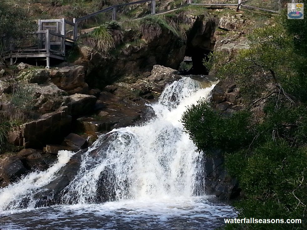
The Blowhole is a small circular tunnel cut through the side of the hill on Sailors Creek near Hepburn Springs that blows hard when the
river level is high. The tunnel outlet is elevated above the downstream creek by several metres, causing the water to spurt out over
the rock face into the pool below.
 Above: The Blowhole outlet under moderate flow conditions
(Order this image)
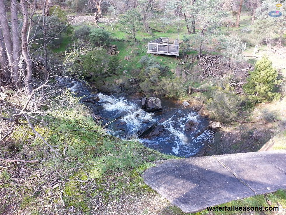
There are several viewing areas at The Blowhole. The walking trail takes you directly over the top of the tunnel, allowing you to see the creek upstream of the tunnel inlet (note: if you look closely in the image above, you can just see the base of the upstream viewing platform through the tunnel window).
The trail then winds down a small ridge to an elevated viewing platform adjacent to the tunnel
outlet. You can also follow the walking trail further down the ridge and across the river to view The Blowhole from opposite the tunnel outlet.
 Above: The Blowhole above the inlet
(Order this image)
According to information boards on site, the 20 metre tunnel was constructed in the 1870s to allow miners to fossick for gold in the dry horshoe bend that was cut off by the tunnel. Given that the creek can be naturally dry for several months of the year, the benefit of the tunnel would have been marginal, and was constructed at a time when other areas had already been picked over.
If you are interested in gold mining activities in the area and want to stretch your legs, The Blowhole is located along the 160 km Goldfields Track
that runs all the way from Creswick to Ballarat.
There are no picnic or toilet facilities at the Blowhole, so most people simply come to take a look as part of their itinerary when taking a day trip or staying in Hepburn Springs or Daylesford. You can also visit The Blowhole in summer to view the tunnel, but chances are there won't be any water running through it.
View Larger Map
 Above: The Blowhole outlet under moderate flow conditions
(Order this image)
There are several viewing areas at The Blowhole. The walking trail takes you directly over the top of the tunnel, allowing you to see the creek upstream of the tunnel inlet (note: if you look closely in the image above, you can just see the base of the upstream viewing platform through the tunnel window).
 Above: The Blowhole above the inlet
(Order this image)
According to information boards on site, the 20 metre tunnel was constructed in the 1870s to allow miners to fossick for gold in the dry horshoe bend that was cut off by the tunnel. Given that the creek can be naturally dry for several months of the year, the benefit of the tunnel would have been marginal, and was constructed at a time when other areas had already been picked over.
There are no picnic or toilet facilities at the Blowhole, so most people simply come to take a look as part of their itinerary when taking a day trip or staying in Hepburn Springs or Daylesford. You can also visit The Blowhole in summer to view the tunnel, but chances are there won't be any water running through it.
Your Seasonal Guide:
| Best Time of Year to Visit: | Best Time of Day to Visit: |
|---|---|
| It is best to visit any time after heavy rainfall. There is reliable flow in winter/spring, but the Blowhole can completely dry up in summer/autumn. | Visit from mid-morning to late afternoon to see the water blowing in full sun. |
Other Information Before You Go:
Location: Hepburn Regional Park, Blowhole Rd, Hepburn Springs, 120 km (approx. 1 hr 30 min drive)
north west of the Melbourne CBD.
Latitude: -37.308966 Longitude: 144.118363
Getting there: From Melbourne head out along the Western Fwy. Exit north from the Western Fwy (M8) at Ballan along the Ballan-Daylesford Rd (C141), passing through both Daylesford and Hepburn Springs. From the Hepburn Springs town centre, head north and then east along Main Road. Turn left at Eighteenth Street, and then right after 1.4 km into Blowhole Road. Blowhole Road is a 1.4 km dirt road that leads to the Blowhole carpark. The road was suitable for 2WD vehicles at the time of my visit. From the car park it is a 100 m walk to the viewing platform.
Water source: Sailors Creek
Approx. height: 3-4 m
Approx. width: 1-4 m, depending on flow conditions
Approx. length: Vertical drop
Swimming available at the falls: Yes, see the swimming hole guide for this site
Facilities: Car parking, viewing platforms, walking trails
Entrance fee: None
Opening times: Always open except for park closures for safety reasons during extreme weather.
Sun shade: Shade available at the outlet of The Blowhole, but limited shade along the walking track and on the viewing platforms.
Wheelchair access: Disabled parking space, but numerous steps down to the viewing platforms.
Prohibitions including whether you can bring your dog: No horseriding, no bicycles, no trail bikes, no diving, fires only permitted in the fire places provided, no access to cliff edges. Dogs permitted but must be on a lead.
Managing authority: Parks Victoria
Nearby attractions: The rest of Hepburn Regional Park including Sailors Falls.
Before you head out, make sure to read the
waterfall safety information and check with the managing authority for any current change of conditions.
The managing authority advises for this
site to not venture off designated walking trails due to the numerous concealed and fragile mine shafts and diggings in the area.
Latitude: -37.308966 Longitude: 144.118363
Getting there: From Melbourne head out along the Western Fwy. Exit north from the Western Fwy (M8) at Ballan along the Ballan-Daylesford Rd (C141), passing through both Daylesford and Hepburn Springs. From the Hepburn Springs town centre, head north and then east along Main Road. Turn left at Eighteenth Street, and then right after 1.4 km into Blowhole Road. Blowhole Road is a 1.4 km dirt road that leads to the Blowhole carpark. The road was suitable for 2WD vehicles at the time of my visit. From the car park it is a 100 m walk to the viewing platform.
Water source: Sailors Creek
Approx. height: 3-4 m
Approx. width: 1-4 m, depending on flow conditions
Approx. length: Vertical drop
Swimming available at the falls: Yes, see the swimming hole guide for this site
Facilities: Car parking, viewing platforms, walking trails
Entrance fee: None
Opening times: Always open except for park closures for safety reasons during extreme weather.
Sun shade: Shade available at the outlet of The Blowhole, but limited shade along the walking track and on the viewing platforms.
Wheelchair access: Disabled parking space, but numerous steps down to the viewing platforms.
Prohibitions including whether you can bring your dog: No horseriding, no bicycles, no trail bikes, no diving, fires only permitted in the fire places provided, no access to cliff edges. Dogs permitted but must be on a lead.
Managing authority: Parks Victoria
Nearby attractions: The rest of Hepburn Regional Park including Sailors Falls.
Locality Map:
The marker indicates the approximate location of the car park at The Blowhole. If the map is not zoomed in locally, as can occur with some browsers, simply refresh this web page.
View Larger Map
Comments:
If you would like to leave a comment about this waterfall, please fill in the comment box below.
I'm particularly interested in your experiences after visiting, and any changes in conditions, etc.
All fields are required if you would like to see your comments appear on this website.
| ← Back | Next Falls → |
| Victoria | Western VIC |
| Safety Info | Map |
| List of Lists | Your Support |
| Feedback | Media |
|
|
|
|
|
|
|
|
|
|
© Brad Neal 2024. All rights reserved. Here are my
affiliate links and cookies policy and opportunities to provide support to Waterfall Seasons.