| ← Back | Next Falls → |
Woolshed Falls, Beechworth, VICWaterfall Seasons - The Waterfall Guide
| Australia |
| Victoria |
| Regions of Victoria: |
| Melbourne |
| Nth East VIC |
| Western VIC |
| Gippsland |
| Other Information: |
| Safety Info |
| Map |
| Accommodation |
| Your Support |
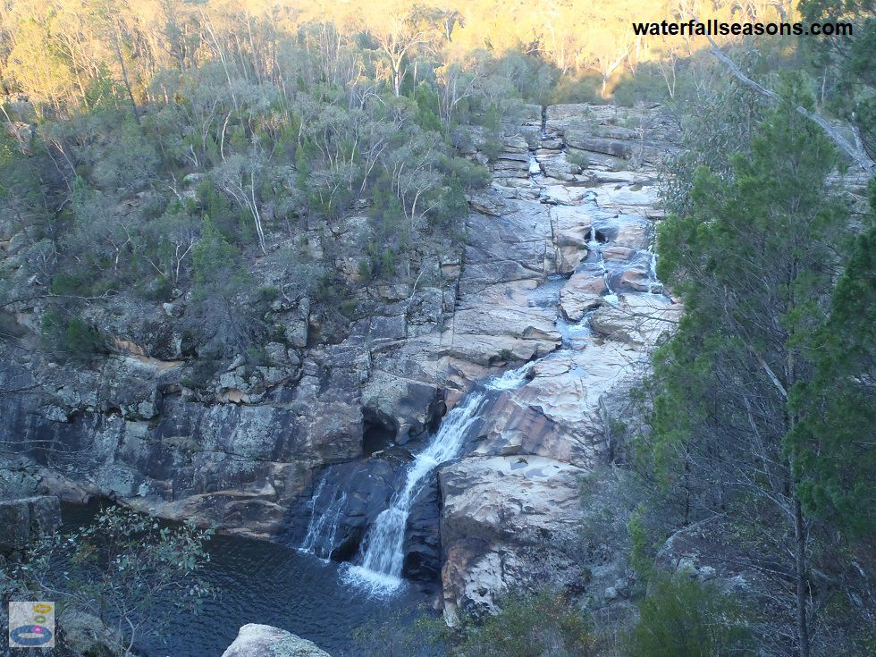
Woolshed Falls is best viewed in early summer, or a day or two after rain in late summer and autumn. I realise this timing is quite prescriptive,
but under these conditions Woolshed Falls will still be gushing, however the flow will be low enough to clamber over the upstream cascades
and maybe even to the pool downstream. At these times you can walk right alongside the falls on bare rock and watch the arc of water spray
out into the air right in front of you.
 Above: Woolshed Falls from the viewing platform
(Order this image)
Access to the falls is quite unrestricted, which is refreshing in this day and age of risk management to the lowest common denominator.
Do not ignore the risks entirely - if you are bringing kids along, as the warning signs say at the falls,
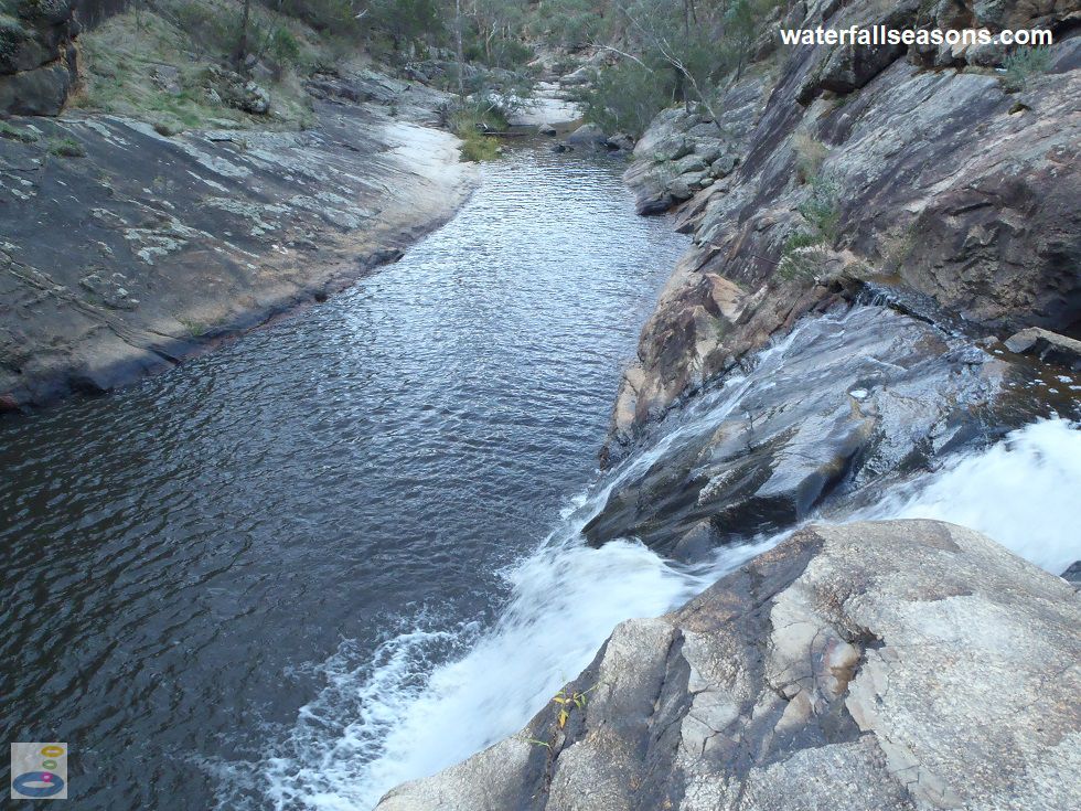
keep a very close eye on them, otherwise they might end up washed downstream to El Dorado. Under low flow conditions you can also follow the
creek to the top of the cascades to view one of the vertical cuts in the bedrock from past gold mining.
 Above: Sitting beside Woolshed Falls, looking towards the trapezoidal rock channel downstream
(Order this image)
After heavy rain this interesting detail upstream is lost and the falls tend to drown out to become more of a large rapid than a waterfall. Still worth seeing, but not as intricate, complex or interactive.
There is a viewing platform located high above the downstream pool with a good overview of the falls. There is also a short walking track from the car park to a very long cut through the rock perpendicular to the main creek, which is a further remnant of past gold mining.
An information board provides details of the history of these rock cuttings and how they were contructed. If you are
taking a gold mining tour of the area, make sure Woolshed Falls is on your list.
Here is a video of the falls, at dusk in late Autumn when the falls were flowing well but you could still jump across the rivulets upstream to cross the falls without getting your feet wet:
View Larger Map
 Above: Woolshed Falls from the viewing platform
(Order this image)
Access to the falls is quite unrestricted, which is refreshing in this day and age of risk management to the lowest common denominator.
 Above: Sitting beside Woolshed Falls, looking towards the trapezoidal rock channel downstream
(Order this image)
After heavy rain this interesting detail upstream is lost and the falls tend to drown out to become more of a large rapid than a waterfall. Still worth seeing, but not as intricate, complex or interactive.
There is a viewing platform located high above the downstream pool with a good overview of the falls. There is also a short walking track from the car park to a very long cut through the rock perpendicular to the main creek, which is a further remnant of past gold mining.
Here is a video of the falls, at dusk in late Autumn when the falls were flowing well but you could still jump across the rivulets upstream to cross the falls without getting your feet wet:
Your Seasonal Guide:
| Best Time of Year to Visit: | Best Time of Day to Visit: |
|---|---|
| Reliable flow all year except during summer/autumn in drought years. Visit in early summer, or a day or two after rain in late summer and autumn for good flow over the falls but not enough to stop you from scrambling amongst the cascades upstream. | Visit from midday onwards to see sunlight bouncing off the falls. Just before dusk you will see the rocks changing colour. Avoid early morning dew or wet days to avoid slipping over in the cascades upstream. |
Other Information Before You Go:
Location: Chiltern-Mt Pilot National Park, McFeeters Road, Beechworth, 290 km (approx. 3 hr 10 minute drive) north-east of the Melbourne CBD.
Latitude:-36.318286 Longitude:146.669211
Getting there: From the Beechworth town centre, head out along Ford St, which then becomes Sydney Road and then the Beechworth-Wodonga Road. A few minutes outside of town, turn left along the Beechworth-Chiltern Road and then left again down McFeeters Road to the park entry. These last two turns are signposted to the falls. From Melbourne, the quickest route is via the Hume Hwy.
Water source: Reedy Creek
Approx. height: 15 m
Approx. width: 2-10 m, depending on flow conditions
Approx. length: The main section of the falls is a near vertical drop, with cascades directly above over a length of around 20 m.
Swimming available at the falls: Order the Guide to Freshwater Swimming Holes in Victoria for more information.
Facilities: Car park, toilets, picnic tables, woodfire barbecues (BYO firewood), information boards
Entrance fee: Not applicable
Opening times: Appeared to be always open, but there is a lockable gate on the entry road
Sun shade: Native bush
Wheelchair access: None
Prohibitions: No pets, no firearms, no fossicking, no bins so take your rubbish home with you
Accommodation Options: See my camping, homestay and hotel suggestions close to Woolshed Falls.
Managing authority: Parks Victoria
Nearby attractions: Lake Sambell in town.
Before you head out, make sure to read the
waterfall safety information and check with the managing authority for any current change of conditions.
Latitude:-36.318286 Longitude:146.669211
Getting there: From the Beechworth town centre, head out along Ford St, which then becomes Sydney Road and then the Beechworth-Wodonga Road. A few minutes outside of town, turn left along the Beechworth-Chiltern Road and then left again down McFeeters Road to the park entry. These last two turns are signposted to the falls. From Melbourne, the quickest route is via the Hume Hwy.
Water source: Reedy Creek
Approx. height: 15 m
Approx. width: 2-10 m, depending on flow conditions
Approx. length: The main section of the falls is a near vertical drop, with cascades directly above over a length of around 20 m.
Swimming available at the falls: Order the Guide to Freshwater Swimming Holes in Victoria for more information.
Facilities: Car park, toilets, picnic tables, woodfire barbecues (BYO firewood), information boards
Entrance fee: Not applicable
Opening times: Appeared to be always open, but there is a lockable gate on the entry road
Sun shade: Native bush
Wheelchair access: None
Prohibitions: No pets, no firearms, no fossicking, no bins so take your rubbish home with you
Accommodation Options: See my camping, homestay and hotel suggestions close to Woolshed Falls.
Managing authority: Parks Victoria
Nearby attractions: Lake Sambell in town.
Locality Map:
The marker indicates the approximate location of the car park next to the falls. If the map is not zoomed in locally, as can occur with some browsers, simply refresh this web page.
View Larger Map
Comments:
If you would like to leave a comment about this waterfall, please fill in the comment box below.
I'm particularly interested in your experiences after visiting, and any changes in conditions, etc.
All fields are required if you would like to see your comments appear on this website.
| ← Back | Next Falls → |
| Victoria | Nth East VIC |
| Safety Info | Map |
| List of Lists | Your Support |
| Feedback | Media |
|
|
|
|
|
|
|
|
|
|
© Brad Neal 2024. All rights reserved. Here are my
affiliate links and cookies policy and opportunities to provide support to Waterfall Seasons.