| ← Back | Next Falls → |
Gibraltar Falls near Canberra, ACTWaterfall Seasons - The Waterfall Guide
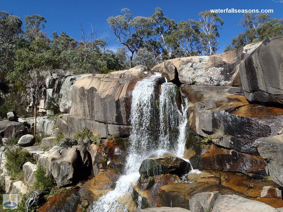
Gibraltar Falls is the only readily accessible waterfall in the ACT. It has a 50 metre
near vertical drop over a granite outcrop, with a viewing platform just below the top lip of the falls, a dizzying view below and
an outlook to the valley downstream.
 Above: Gibraltar Falls from the viewing platform
(Order this image)
The falls are an 80 metre walk from the car park, down a well defined dirt track with some stone steps. When you reach the end of the path, the view opens out to reveal a fenced platform perched on one flank of the falls, about 10 metres below the top of the cliff face.
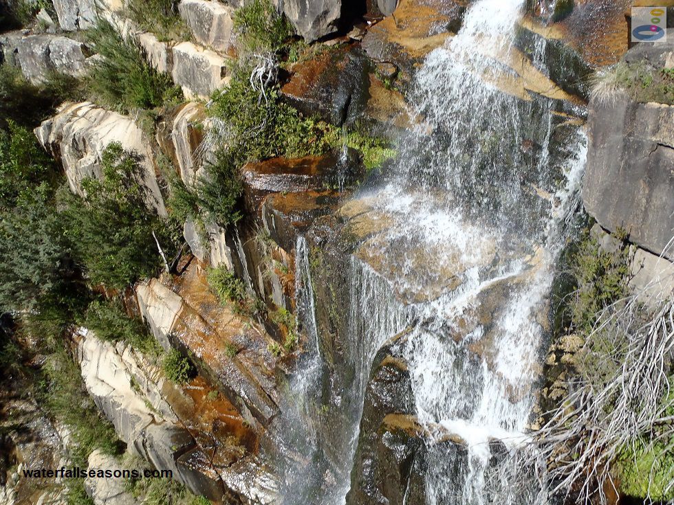
You can lean over the rail and follow the water as it steps down the right angled ledges to the valley floor, with shades of grey, green and orange all
prominent on the rock face. The platform also provides stunning views of the Gibraltar Creek and Paddys River valleys below, and the surrounding mountains.
 Above: The steps down the face of Gibraltar Falls
(Order this image)
You can access the creek above the falls, although this is strongly discouraged by the managing authority for safety reasons, with numerous signs advising you not to enter this area. Whilst the access to this area is easy, the rock surface is very smooth and slippery, and would be difficult to maintain your footing in even slightly damp conditions.
There is a small, shallow pool on the edge of the cliff which is popular for bathing - you can read more about that on
Swimming Hole Heaven.
Back up at the car park there are a couple of picnic tables and barbecues and a lawn area next to the creek. The car park is only small, so it could be difficult to find a spot on busy weekends, so have a backup plan if you are planning to have a picnic here on the weekend.
Here is a video of the falls, taken mid-morning in Autumn, when the creek was flowing, but not in flood, which includes the area upstream and downstream of the falls, and a view of the picnic facilities:
View Larger Map
 Above: Gibraltar Falls from the viewing platform
(Order this image)
The falls are an 80 metre walk from the car park, down a well defined dirt track with some stone steps. When you reach the end of the path, the view opens out to reveal a fenced platform perched on one flank of the falls, about 10 metres below the top of the cliff face.
 Above: The steps down the face of Gibraltar Falls
(Order this image)
You can access the creek above the falls, although this is strongly discouraged by the managing authority for safety reasons, with numerous signs advising you not to enter this area. Whilst the access to this area is easy, the rock surface is very smooth and slippery, and would be difficult to maintain your footing in even slightly damp conditions.
Back up at the car park there are a couple of picnic tables and barbecues and a lawn area next to the creek. The car park is only small, so it could be difficult to find a spot on busy weekends, so have a backup plan if you are planning to have a picnic here on the weekend.
Here is a video of the falls, taken mid-morning in Autumn, when the creek was flowing, but not in flood, which includes the area upstream and downstream of the falls, and a view of the picnic facilities:
Your Seasonal Guide:
| Best Time of Year to Visit: | Best Time of Day to Visit: |
|---|---|
| The reliability of this stream is unknown because flows over the falls are not recorded, however the falls were still flowing when I visited in late April after a relatively hot and dry summer and autumn. Visit after rainfall to see the falls at their most spectacular from the viewing platform. | Visit any time of the day to see the falls in full sun. Fog can sometimes make driving to the falls difficult on still mornings in winter. |
Other Information Before You Go:
Note: As at February 2023, access to Gibraltar Falls was closed by the managing authority whilst they review site safety after
two deaths at the falls in February 2023. Review and implementation of any new measures is likely to take a while given the recent loss of life here. This
advice is current as of last checking in February 2024.
Location: Corin Road, Paddys River, 45 km (approx. 45 minute drive) south-west of Canberra Central
Latitude:-35.487679 Longitude:148.933980
Getting there: From Canberra take the Tuggeranong Parkway (aka Drakeford Dr), Monaro Hwy or Yamba Drive south to the suburb of Gordon. From Gordon take Point Hut Road across the Murrumbidgee River for 4 km then turn right into Tidbinbilla Road and follow it for 6 km, then head left into Corin Road. Follow Corin Road for 6 km and look for the sign to the Gibraltar Falls car park on the left. The road to the falls car park is sealed. To reach the falls there is an 80 metre walk down some steps to the viewing platform.
Water source: Gibraltar Creek
Approx. height: 50 m
Approx. width: 1 to 5 m, depending on flow conditions and location along the falls
Approx. length: Near vertical drop
Swimming available at the falls: You can read here about bathing in the shallow pool above the falls
Facilities: Toilets, bbqs, picnic tables, lawn area, car park
Entrance fee: None
Opening times: Always open
Sun shade: No shade at the falls platform, but some natural shade at the picnic tables and barbecues
Wheelchair access: None
Prohibitions: All plants, animals and their habitat are protected, do not remove or interfere with historic sites or artefacts. No dogs.
Managing authority: ACT Government
Nearby attractions: There is a snow play area and all-year round toboggan ride at Corin Forest a few kilometres further up Corin Road.
Before you head out, make sure to read the
waterfall safety information and check with the managing authority for any current change of conditions.
Specific to this site, the managing authority advises not to walk out onto the area above the falls due to the steep cliffs.
Latitude:-35.487679 Longitude:148.933980
Getting there: From Canberra take the Tuggeranong Parkway (aka Drakeford Dr), Monaro Hwy or Yamba Drive south to the suburb of Gordon. From Gordon take Point Hut Road across the Murrumbidgee River for 4 km then turn right into Tidbinbilla Road and follow it for 6 km, then head left into Corin Road. Follow Corin Road for 6 km and look for the sign to the Gibraltar Falls car park on the left. The road to the falls car park is sealed. To reach the falls there is an 80 metre walk down some steps to the viewing platform.
Water source: Gibraltar Creek
Approx. height: 50 m
Approx. width: 1 to 5 m, depending on flow conditions and location along the falls
Approx. length: Near vertical drop
Swimming available at the falls: You can read here about bathing in the shallow pool above the falls
Facilities: Toilets, bbqs, picnic tables, lawn area, car park
Entrance fee: None
Opening times: Always open
Sun shade: No shade at the falls platform, but some natural shade at the picnic tables and barbecues
Wheelchair access: None
Prohibitions: All plants, animals and their habitat are protected, do not remove or interfere with historic sites or artefacts. No dogs.
Managing authority: ACT Government
Nearby attractions: There is a snow play area and all-year round toboggan ride at Corin Forest a few kilometres further up Corin Road.
Locality Map:
The marker indicates the approximate location of the car park at the falls. If the map is not zoomed in locally, as can occur with some browsers, simply refresh this web page.
View Larger Map
Comments:
If you would like to leave a comment about this waterfall, please fill in the comment box below.
I'm particularly interested in your experiences after visiting, and any changes in conditions, etc.
All fields are required if you would like to see your comments on this website.
| ← Back | Next Falls → |
| Australia | NSW / ACT |
| Safety Info | Map |
| List of Lists | Your Support |
| Feedback | Media |
|
|
|
|
|
|
|
|
|
|
© Brad Neal 2024. All rights reserved. Here are my
affiliate links and cookies policy and opportunities to provide support to Waterfall Seasons.