| ← Back | Next Falls → |
Dangar Falls, Dorrigo NSWWaterfall Seasons - The Waterfall Guide
Just a few steps from the car park, step out onto the elevated platform to see Dangar Falls thundering over a basalt cliff into a broad circular pool below. You can also wander down through the rainforest to the water's edge.
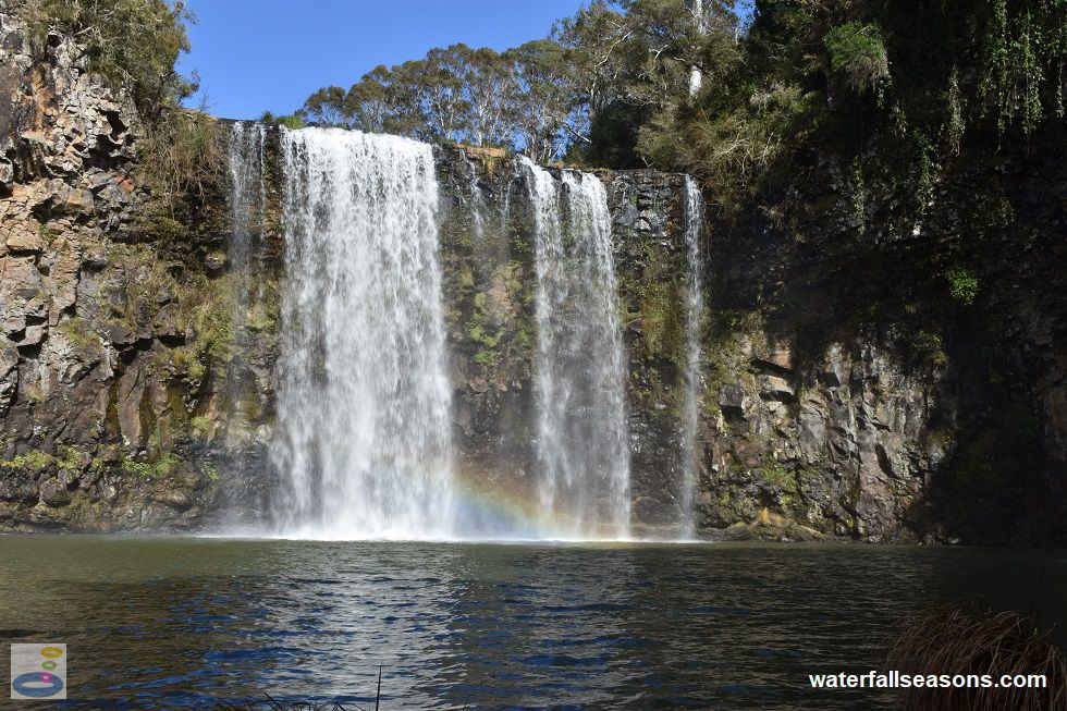
 Above: Dangar Falls from the shore of the Bielsdown River
(Order this image)
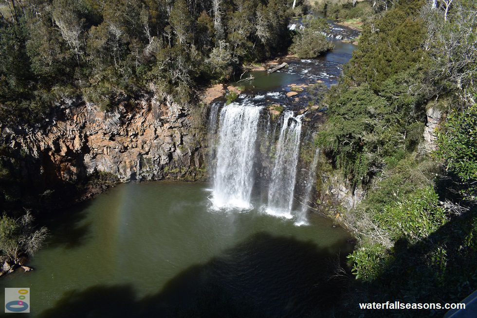
The falls are concealed from view from the car park, but can be heard straight away after opening the car door. Even as I approached the viewing platform I had no idea what lay below until I was leaning up against the platform railing. Then as I peered over the edge, the ground dropped away, taking my breath with it, to suddenly reveal a broad, powerful torrent of water crashing down into a large pool.
On my visit it was a bit windy, so I was also treated to a small rainbow at the base of the falls. The spray from the falls was picked up by the wind, dancing colourfully as it was illuminated by the morning sunlight.
 Above: Dangar Falls from the readily accessible viewing platform
(Order this image)
The walk down to the base of the falls is mostly via sturdy wooden boardwalks with steps, leading to a small wooden viewing platform directly in front of the falls. There was one section where the track was angled awkwardly with a slope from one side, but otherwise more easily navigable than suggested by the warning signs on site.
To reach the water's edge it did however involve stepping over slippery, uneven ground that was muddy in parts. The walk also
goes via the Labyrinth, a series of intertwined circular pathways leading to either dead ends or a central point, depending on the path you take.
The picnic ground at the falls is great for family picnics, with a playground containing a variety of play equipment, some undercover public bbqs, and the option of either using the picnic tables or spreading a blanket out on the ground. All of this is easily accessible from the car park.
Here is a quick video of the falls taken in winter on a clear but windy morning when the falls were flowing quite strongly.
View Larger Map
 Above: Dangar Falls from the shore of the Bielsdown River
(Order this image)
The falls are concealed from view from the car park, but can be heard straight away after opening the car door. Even as I approached the viewing platform I had no idea what lay below until I was leaning up against the platform railing. Then as I peered over the edge, the ground dropped away, taking my breath with it, to suddenly reveal a broad, powerful torrent of water crashing down into a large pool.
 Above: Dangar Falls from the readily accessible viewing platform
(Order this image)
The walk down to the base of the falls is mostly via sturdy wooden boardwalks with steps, leading to a small wooden viewing platform directly in front of the falls. There was one section where the track was angled awkwardly with a slope from one side, but otherwise more easily navigable than suggested by the warning signs on site.
The picnic ground at the falls is great for family picnics, with a playground containing a variety of play equipment, some undercover public bbqs, and the option of either using the picnic tables or spreading a blanket out on the ground. All of this is easily accessible from the car park.
Here is a quick video of the falls taken in winter on a clear but windy morning when the falls were flowing quite strongly.
Your Seasonal Guide:
| Best Time of Year to Visit: | Best Time of Day to Visit: |
|---|---|
| Flow has historically been continuous over the falls all year round, with highest flows typically from February to April | Visit in the morning to see the falls in full sun |
Other Information Before You Go:
Location: Dangar Falls / Biyurrgung-Birrugan-Gumburr guluun-ngarrlu naan.gal, Coramba Road, Dorrigo, 1.7 km north of the Dorrigo town centre and 550 km (approx. 6 hr 30 min drive) north of the Sydney CBD.
Latitude:-30.323095 Longitude:152.713258
Getting there: From the Pacific Highway at Raleigh, head west along Waterfall Way (B78) to Dorrigo. From the Dorrigo town centre head north along Hickory St and then Vine St, which then becomes Coramba Rd, until you reach the car park for the falls. The viewing platform is next to the car park, with a 200 metre walking track that leads down to the base of the falls.
Water source: Bielsdown River
Approx. height: 30 metres
Approx. width: 10 metres
Approx. length: Vertical drop
Swimming available at the falls: Yes
Facilities: At the top of the falls, there is a car park, viewing platform, shaded playground, lawn area, public toilets, uncovered picnic tables, covered picnic tables, public bbqs, rubbish bins, information boards
Entrance fee: None
Opening times: Always open
Sun shade: Shade available at the picnic area and along the walk. Shade is limited in the middle of the day at the base of the falls.
Wheelchair access: The viewing platform is wheelchair accessible. Wheelchair accessible toilets and priority parking in the car park.
Prohibitions: Rubbish bins are for park users only. Dogs permitted.
Accommodation Options: See my accommodation suggestions close to Dangar Falls.
Managing authority: NSW National Parks and Wildlife Service
Nearby attractions: Crystal Shower Falls in Dorrigo National Park and other waterfalls along Waterfall Way
Before you head out, make sure to read the
waterfall safety information and check with the managing authority for any current change of conditions. Specific to this site, the managing authority
warns that the walking track includes steep and uneven sections and to please watch your step. It also advises to never jump from the top of the falls, to stay behind railings and barriers,
to not jump into the swimming holes or river, to not swim after heavy rain, to never swim alone, to please keep sunscreen and insect repellent and soaps out of the water, and to stay on the tracks
and keep off any regeneration areas. Lastly it advises that during drought periods, water quality may be unsafe for swimming.
Latitude:-30.323095 Longitude:152.713258
Getting there: From the Pacific Highway at Raleigh, head west along Waterfall Way (B78) to Dorrigo. From the Dorrigo town centre head north along Hickory St and then Vine St, which then becomes Coramba Rd, until you reach the car park for the falls. The viewing platform is next to the car park, with a 200 metre walking track that leads down to the base of the falls.
Water source: Bielsdown River
Approx. height: 30 metres
Approx. width: 10 metres
Approx. length: Vertical drop
Swimming available at the falls: Yes
Facilities: At the top of the falls, there is a car park, viewing platform, shaded playground, lawn area, public toilets, uncovered picnic tables, covered picnic tables, public bbqs, rubbish bins, information boards
Entrance fee: None
Opening times: Always open
Sun shade: Shade available at the picnic area and along the walk. Shade is limited in the middle of the day at the base of the falls.
Wheelchair access: The viewing platform is wheelchair accessible. Wheelchair accessible toilets and priority parking in the car park.
Prohibitions: Rubbish bins are for park users only. Dogs permitted.
Accommodation Options: See my accommodation suggestions close to Dangar Falls.
Managing authority: NSW National Parks and Wildlife Service
Nearby attractions: Crystal Shower Falls in Dorrigo National Park and other waterfalls along Waterfall Way
Locality Map:
The marker indicates the approximate location of the car park at the falls. If the map is not zoomed in locally, as can sometimes occur when loading, simply click or tap on "View Larger Map" below.
View Larger Map
Comments:
If you would like to leave a comment about this waterfall, please fill in the comment box below.
I'm particularly interested in your experiences after visiting, and any changes in conditions, etc.
All fields are required if you would like to see your comments on this website.
| ← Back | Next Falls → |
| Australia | NSW / ACT |
| Safety Info | Map |
| List of Lists | Your Support |
| Feedback | Media |
|
|
|
|
|
|
|
|
|
|
© Brad Neal 2024. All rights reserved. Here are my
affiliate links and cookies policy and opportunities to provide support to Waterfall Seasons.