| ← Back | Next Falls → |
Serenity Falls (aka Buderim Falls)Waterfall Seasons - The Waterfall Guide
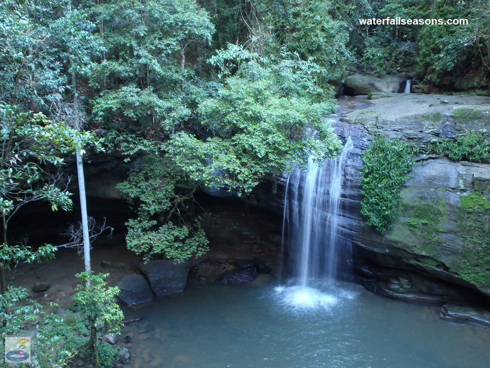
A fine silver curtain of water falls delicately into a rock chasm surrounded by the lush rainforest of the Buderim Forest Park on the Sunshine Coast. Despite feeling a world
away from civilisation, this waterfall is surprisingly close to the town of Buderim and is easily accessible by road from Maroochydore and
Mooloolaba. There are steps leading down to the water's edge and at the time of my visit, it was also possible to creep in under the rock ledge to sneak in behind the
curtain.
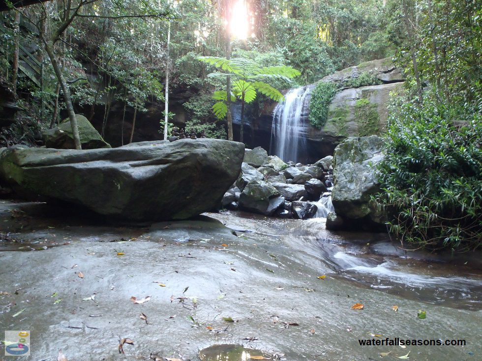
 Above: The slab of rock and downstream pool at Buderim Falls
(Order this image)
On the local signage, the falls are mostly just referred to as the "waterfall", without being named, but in fine print on some of the signs the falls are clearly named "Serenity Falls", which is an apt name considering the ambience of this place. Some information sources, such as on Google Maps, refer to the falls simply as "Buderim Falls".
Wandering downstream along the rock shelf beside the creek, there was an ancient, enclosed feel to this place, from the steep sided walls of the gully, sunlight that struggled to penetrate through the dense canopy, tall tree ferns and moss covered rocks so large as to seem immovable.
In addition to the main waterfall, there are several cascades downstream that you can explore by foot, including a junction of two cascading creeks into shallow
pools. For some exercise you can walk around the loop track that takes you around the rim of the gully, but it does not offer any better views of the falls. Apart
from the poolside view, there is a footbridge that crosses the creek which gives you an uninterrupted, elevated view of the falls.
 Above: The gully downstream of Serenity Falls
(Order this image)
You can access the falls via a short walk from car parks located upstream and downstream. Most people tend to follow the boardwalks that run beside the creek from Harry's Lane, north of the falls. On my visit part of the boardwalk was washed away from recent flooding and the track was extremely muddy in those missing sections. The shorter but less scenic route is from Quorn Close above the falls, where you can also find an Edna Walling tribute garden.
Edna Walling was a landscaper who was famous
for her cottage gardens in Melbourne, before retiring to the Buderim area, where she continued to design some local gardens.
Here is a video that I took when visiting the falls in Autumn. There was plenty of water flowing over the falls, but not enough to prevent me getting in behind the rock ledge, and exploring the creek bed downstream:
View Larger Map
 Above: The slab of rock and downstream pool at Buderim Falls
(Order this image)
On the local signage, the falls are mostly just referred to as the "waterfall", without being named, but in fine print on some of the signs the falls are clearly named "Serenity Falls", which is an apt name considering the ambience of this place. Some information sources, such as on Google Maps, refer to the falls simply as "Buderim Falls".
Wandering downstream along the rock shelf beside the creek, there was an ancient, enclosed feel to this place, from the steep sided walls of the gully, sunlight that struggled to penetrate through the dense canopy, tall tree ferns and moss covered rocks so large as to seem immovable.
 Above: The gully downstream of Serenity Falls
(Order this image)
You can access the falls via a short walk from car parks located upstream and downstream. Most people tend to follow the boardwalks that run beside the creek from Harry's Lane, north of the falls. On my visit part of the boardwalk was washed away from recent flooding and the track was extremely muddy in those missing sections. The shorter but less scenic route is from Quorn Close above the falls, where you can also find an Edna Walling tribute garden.
Here is a video that I took when visiting the falls in Autumn. There was plenty of water flowing over the falls, but not enough to prevent me getting in behind the rock ledge, and exploring the creek bed downstream:
Your Seasonal Guide:
| Best Time of Year to Visit: | Best Time of Day to Visit: |
|---|---|
| There is a reliable flow over the falls all year round, with the highest flows typically from December through to June | Visit during the middle of the day when sunlight pierces through the forest to shine on the falls |
Other Information Before You Go:
Location: Buderim Forest Park, roughly 7-8 km south-west of Maroochydore, or 90 km (approx. 1 hour 20 min drive) north of Brisbane.
Latitude:-26.677954 Longitude:153.047809
Getting there: From the Sunshine Motorway (route 70), follow Mooloolaba Road / King St to Buderim. From the roundabout in town, head down Lindsay Road and then turn right into Quorn Close. There is a car park right at the end of Quorn Close. The walk from here is 300 metres downhill to the falls. Alternatively, from Maroochydore exit the Sunshine Motorway at Maroochydore Road, and then turn south onto Jones Road. Shortly after entering Jones Road, turn right into Lindsay Road, then after 800 metres turn left into Harrys Lane, where you will find roadside parking. From Harrys Lane, it is a 1 km walk slightly uphill to the falls.
Water source: Martins Creek
Approx. height: 8-10 metres
Approx. width: 1 metre
Approx. length: 5-10 metres
Swimming available at the falls: The managing authority advises that swimming here is dangerous after heavy rainfall due to debris and contaminants from upstream.
Facilities: None at the falls. At Quorn Close there is a car park, free public barbecues, sheltered picnic tables, a water tap, rubbish bins and toilets. At Harrys Lane there is a restaurant, lawn, free public barbecues, picnic tables, toilets, and a boardwalk.
Entrance fee: None
Opening times: Always open
Sun shade: Shade available at the falls. Both of the picnic areas have access to shade.
Wheelchair access: None to the falls, but toilets at both car parks are wheelchair accessible. The first 600 metres of the boardwalk through the forest from Harrys Lane is wheelchair accessible, but wheelchair access finishes about 400 metres short of the falls.
Prohibitions including whether you can bring your dog: No dogs
Managing authority: Shire of Maroochy
Nearby attractions: The rest of the Sunshine Coast.
Before you head out, make sure you read the
waterfall safety information and check with the managing authority for any current change of conditions.
Latitude:-26.677954 Longitude:153.047809
Getting there: From the Sunshine Motorway (route 70), follow Mooloolaba Road / King St to Buderim. From the roundabout in town, head down Lindsay Road and then turn right into Quorn Close. There is a car park right at the end of Quorn Close. The walk from here is 300 metres downhill to the falls. Alternatively, from Maroochydore exit the Sunshine Motorway at Maroochydore Road, and then turn south onto Jones Road. Shortly after entering Jones Road, turn right into Lindsay Road, then after 800 metres turn left into Harrys Lane, where you will find roadside parking. From Harrys Lane, it is a 1 km walk slightly uphill to the falls.
Water source: Martins Creek
Approx. height: 8-10 metres
Approx. width: 1 metre
Approx. length: 5-10 metres
Swimming available at the falls: The managing authority advises that swimming here is dangerous after heavy rainfall due to debris and contaminants from upstream.
Facilities: None at the falls. At Quorn Close there is a car park, free public barbecues, sheltered picnic tables, a water tap, rubbish bins and toilets. At Harrys Lane there is a restaurant, lawn, free public barbecues, picnic tables, toilets, and a boardwalk.
Entrance fee: None
Opening times: Always open
Sun shade: Shade available at the falls. Both of the picnic areas have access to shade.
Wheelchair access: None to the falls, but toilets at both car parks are wheelchair accessible. The first 600 metres of the boardwalk through the forest from Harrys Lane is wheelchair accessible, but wheelchair access finishes about 400 metres short of the falls.
Prohibitions including whether you can bring your dog: No dogs
Managing authority: Shire of Maroochy
Nearby attractions: The rest of the Sunshine Coast.
Locality Map:
The marker indicates the approximate location of the start of the walk to the falls from Quorn Close. If the map is not zoomed in locally, as can occur with some browsers, simply refresh this web page.
View Larger Map
Comments:
If you would like to leave a comment about this waterfall, please fill in the comment box below.
I'm particularly interested in your experiences after visiting, and any changes in conditions, etc.
All fields are required if you would like to see your comments appear on this website.
| ← Back | Next Falls → |
| Australia | Queensland |
| Safety Info | Map |
| List of Lists | Your Support |
| Feedback | Media |
|
|
|
|
|
|
|
|
|
|
© Brad Neal 2024. All rights reserved. Here are my
affiliate links and cookies policy and opportunities to provide support to Waterfall Seasons.