| ← Back | Next Falls → |
Wappa FallsWaterfall Seasons - The Waterfall Guide
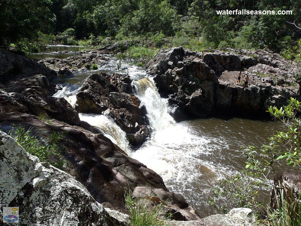
Regular spills from a dam directly upstream make this an at times powerful twin waterfall in the Sunshine Coast hinterland. The falls split around
a bulging rock head before plunging down into a circular pool of turbulent water below. The falls are not particularly high, but they can pack a
punch as the two streams are squeezed on either side and then swirl together in a frothy cauldron of white and tan. In times of low rainfall, when
the dam is not spilling, the falls and the pool downstream can be quite tranquil.
 Above: The twin falls bifurcating at Wappa Falls
(Order this image)
There are no facilities as such at the falls, and space up on the rim of the rock wall near the car park was limited. There was also a fair bit of water seeping out from the soil, that made patches of the ground quite wet after rainfall earlier in the week before my visit.
From the car park, I was able to wander around to the top of the falls across open ground quite easily, where you will find a comparatively peaceful stream. To
access the base of the falls, head right from the car park where you will find a track that winds around and down some steps to the river. Depending
on the water level, there can be several elevated rock pools full of water, stranded from previous high flows. There are plenty of sun-drenched places on the rock shelves
that surround the pool to sit down and enjoy the view.
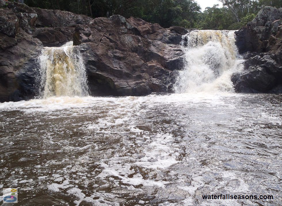
 Above: The raging torrent mixing in the cauldron at Wappa Falls
(Order this image)
For those who are interested, upstream Wappa Dam is maintained at capacity most of the time, meaning that it spills water down through the falls most of the time. When the dam is below capacity, as it typically is for up to several months roughly every second year on average, there is very little water passing through the falls.
If you want to check whether the dam is spilling before you go, you can download an app from the seqwater website that gives you notifications of
when it is spilling, or search for "latest dam levels" on seqwater's website. The periods of reservoir drawdown, when the dam is not spilling, are not strongly seasonal, but
appear to occur more often over the summer months than in winter.
Here is a video that I took when visiting the falls in Autumn when the upstream dam was spilling:
View Larger Map
 Above: The twin falls bifurcating at Wappa Falls
(Order this image)
There are no facilities as such at the falls, and space up on the rim of the rock wall near the car park was limited. There was also a fair bit of water seeping out from the soil, that made patches of the ground quite wet after rainfall earlier in the week before my visit.
 Above: The raging torrent mixing in the cauldron at Wappa Falls
(Order this image)
For those who are interested, upstream Wappa Dam is maintained at capacity most of the time, meaning that it spills water down through the falls most of the time. When the dam is below capacity, as it typically is for up to several months roughly every second year on average, there is very little water passing through the falls.
Here is a video that I took when visiting the falls in Autumn when the upstream dam was spilling:
Your Seasonal Guide:
| Best Time of Year to Visit: | Best Time of Day to Visit: |
|---|---|
| As noted above, visit when upstream Wappa Dam is spilling | The falls will be in full sun from mid-morning to mid-afternoon |
Other Information Before You Go:
Location: At the end of Pump Station Road, Kiamba, 4 km west of Yandina and 110 km north of Brisbane
Latitude:-26.570845 Longitude:152.924931
Getting there: From the Bruce Hwy (M1) turn off at Yandina. Wappa Falls Road is approximately 1 km south of the town centre along the Nambour Connection Road (aka Farrell St). After 3-4 km along Wappa Falls Road, head north down Pump Station Road. The falls are a few metres from the car park at the end of Pump Station Road.
Water source: Wappa Dam / South Maroochy River
Approx. height: 5 metres
Approx. width: 1 metre in each of the two streams
Approx. length: 5-6 metres
Swimming available at the falls: Yes, more info here
Facilities: Car park. No other facilities. Jack Harrison Park has picnic facilities a few hundred metres further up Wappa Falls Road, at Wappa Dam.
Entrance fee: None
Opening times: Always open
Sun shade: Shade available near the car park, but limited to no shade on the rock around the base of the falls.
Wheelchair access: None
Prohibitions including whether you can bring your dog: No diving. There were no signs on site indicating that you cannot bring your dog.
Managing authority: Queensland Government
Nearby attractions: The Ginger Factory in Yandina
Before you head out, make sure you read the
waterfall safety information and check with the managing authority for any current change of conditions.
Latitude:-26.570845 Longitude:152.924931
Getting there: From the Bruce Hwy (M1) turn off at Yandina. Wappa Falls Road is approximately 1 km south of the town centre along the Nambour Connection Road (aka Farrell St). After 3-4 km along Wappa Falls Road, head north down Pump Station Road. The falls are a few metres from the car park at the end of Pump Station Road.
Water source: Wappa Dam / South Maroochy River
Approx. height: 5 metres
Approx. width: 1 metre in each of the two streams
Approx. length: 5-6 metres
Swimming available at the falls: Yes, more info here
Facilities: Car park. No other facilities. Jack Harrison Park has picnic facilities a few hundred metres further up Wappa Falls Road, at Wappa Dam.
Entrance fee: None
Opening times: Always open
Sun shade: Shade available near the car park, but limited to no shade on the rock around the base of the falls.
Wheelchair access: None
Prohibitions including whether you can bring your dog: No diving. There were no signs on site indicating that you cannot bring your dog.
Managing authority: Queensland Government
Nearby attractions: The Ginger Factory in Yandina
Locality Map:
The marker indicates the approximate location of the parking area at the falls. If the map is not zoomed in locally, as can occur with some browsers, simply refresh this web page.
View Larger Map
Comments:
If you would like to leave a comment about this waterfall, please fill in the comment box below.
I'm particularly interested in your experiences after visiting, and any changes in conditions, etc.
All fields are required if you would like to see your comments appear on this website.
| ← Back | Next Falls → |
| Australia | Queensland |
| Safety Info | Map |
| List of Lists | Your Support |
| Feedback | Media |
|
|
|
|
|
|
|
|
|
|
© Brad Neal 2024. All rights reserved. Here are my
affiliate links and cookies policy and opportunities to provide support to Waterfall Seasons.