| ← Home page | Next Falls → |
Wattamolla Falls, Royal National Park, NSWWaterfall Seasons - The Waterfall Guide
A fence protects you from falling off this sandstone cliff, but there is nothing to protect you from the water dragons at these falls in the Royal
National Park, south of Sydney.
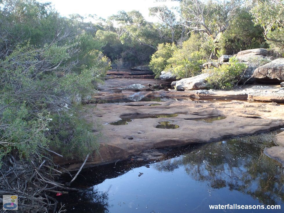
 Above: The upper section of Wattamolla Falls on Coote Creek
(Order this image)
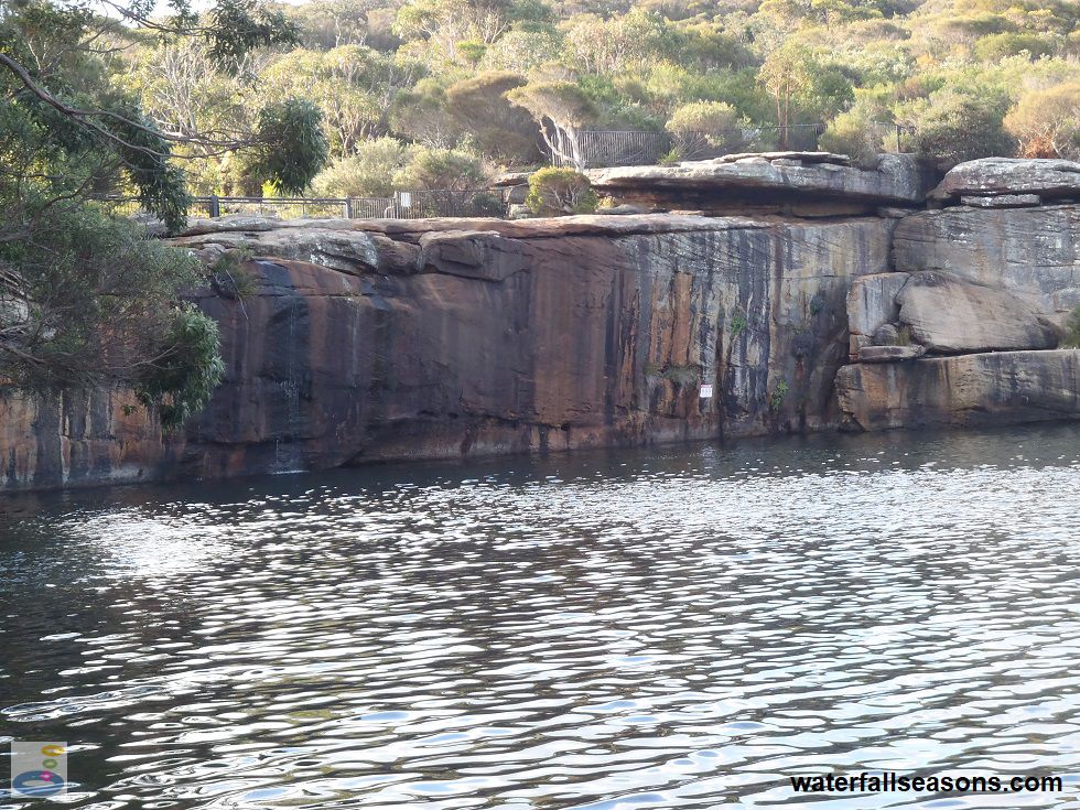
The falls run over a series of pockmarked sandstone slabs before reaching the final drop of more than ten metres over the cliff edge, down into the lagoon below. You can walk across the creek, which is part of the walking track to nearby Wattamolla Dam. The falls are incredibly easy to reach, being only a few steps away from the car park and grassy picnic area.
The views from the top of the falls, out over the lagoon towards Wattamolla Beach, are spectacular.
 Above: The sandstone cliff that forms Wattamolla Falls
(Order this image)
You can walk down to the base of the falls via a path that leads down to the lagoon, but it is a fifty metre swim back to the waterfall if you want to see it up close.
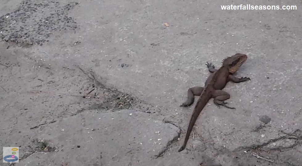
The top of the falls is also home to a colony of water dragons that bathe in the sunshine on the warm sandstone rocks.
Slightly alarming because of their size of around 1 metre in length (these are not small lizards), they seemed to tolerate people coming to within a couple of metres
of them before scurrying off to find a different spot to sunbake.
 Above: A water dragon at the top of Wattamolla Falls
(Order this image)
View Larger Map
 Above: The upper section of Wattamolla Falls on Coote Creek
(Order this image)
The falls run over a series of pockmarked sandstone slabs before reaching the final drop of more than ten metres over the cliff edge, down into the lagoon below. You can walk across the creek, which is part of the walking track to nearby Wattamolla Dam. The falls are incredibly easy to reach, being only a few steps away from the car park and grassy picnic area.
 Above: The sandstone cliff that forms Wattamolla Falls
(Order this image)
You can walk down to the base of the falls via a path that leads down to the lagoon, but it is a fifty metre swim back to the waterfall if you want to see it up close.
The top of the falls is also home to a colony of water dragons that bathe in the sunshine on the warm sandstone rocks.
 Above: A water dragon at the top of Wattamolla Falls
(Order this image)
Your Seasonal Guide:
| Best Time of Year to Visit: | Best Time of Day to Visit: |
|---|---|
| Visit after rainfall to see water flowing over the falls, as Coote Creek has only a small catchment and will otherwise be dry | Visit from mid-morning onwards to avoid looking into the sun from the top of the falls |
Other Information Before You Go:
Location: Wattamolla Falls, Royal National Park, near Heathcote, 48 km (approx. 1 hr 20 min drive) south of the Sydney CBD.
Latitude:-34.137033 Longitude:151.115639
Getting there: From the city head south along the Princes Hwy (A1/M1) then follow the signs to Royal National Park along Farnell Ave at Loftus. Follow Farnell Ave / Audley Rd / Sir Bertram Stevens Drive to Wattamolla Road, which leads to the car park at the falls. The lookout above the falls is at the northern end of the car park, whilst the paths leading down to the water are accessible from near the southern end of the car park. All roads were 2WD accessible on my visit. According to the managing authority, the number of visitors on a weekend often exceeds the available number of car parks, so have a backup plan to visit somewhere else nearby if the car park is full.
Water source: Coote Creek
Approx. height: 10-12 m
Approx. width: 1-5 m, depending on flow conditions
Approx. length: Vertical drop
Swimming available at the falls: Yes, see here for details
Facilities: Public toilets, picnic tables, gas/electric barbecues, car park, walking trails
Entrance fee: There is a nominal fee per vehicle for access to Royal National Park
Opening times: Open 7 am to 8.30 pm daily. There are gates on Wattamolla Road that close at night.
Sun shade: Limited to no shade at the falls and in the picnic area
Wheelchair access: Access to the top of the falls, but the descent down to the lagoon is quite steep.
Prohibitions: No campfires, no solid fuel burners, no gathering firewood, no pets, no smoking, no jumping or diving off the falls, no climbing the fence, no littering, no camping
Managing authority: NSW National Parks and Wildlife Service
Nearby attractions: Wattamolla Creek Dam, a 700 metre walk to the north, or National Falls, also in the Royal National Park.
Before you head out, make sure to read the
waterfall safety information and check with the managing authority for any current change of conditions. Specific to this site, the managing authority advises
on site that there is no lifesaving service, children need to be supervised, there can be unexpected large
waves and strong currents, shallow water, sudden drop offs and slippery rocks. The managing authority urges
visitors to use extreme caution when the creek is open to the sea.
Latitude:-34.137033 Longitude:151.115639
Getting there: From the city head south along the Princes Hwy (A1/M1) then follow the signs to Royal National Park along Farnell Ave at Loftus. Follow Farnell Ave / Audley Rd / Sir Bertram Stevens Drive to Wattamolla Road, which leads to the car park at the falls. The lookout above the falls is at the northern end of the car park, whilst the paths leading down to the water are accessible from near the southern end of the car park. All roads were 2WD accessible on my visit. According to the managing authority, the number of visitors on a weekend often exceeds the available number of car parks, so have a backup plan to visit somewhere else nearby if the car park is full.
Water source: Coote Creek
Approx. height: 10-12 m
Approx. width: 1-5 m, depending on flow conditions
Approx. length: Vertical drop
Swimming available at the falls: Yes, see here for details
Facilities: Public toilets, picnic tables, gas/electric barbecues, car park, walking trails
Entrance fee: There is a nominal fee per vehicle for access to Royal National Park
Opening times: Open 7 am to 8.30 pm daily. There are gates on Wattamolla Road that close at night.
Sun shade: Limited to no shade at the falls and in the picnic area
Wheelchair access: Access to the top of the falls, but the descent down to the lagoon is quite steep.
Prohibitions: No campfires, no solid fuel burners, no gathering firewood, no pets, no smoking, no jumping or diving off the falls, no climbing the fence, no littering, no camping
Managing authority: NSW National Parks and Wildlife Service
Nearby attractions: Wattamolla Creek Dam, a 700 metre walk to the north, or National Falls, also in the Royal National Park.
Locality Map:
The marker indicates the approximate location of the falls. If the map is not zoomed in locally, as can sometimes occur when loading, simply click or tap on "View Larger Map" below.
View Larger Map
Comments:
If you would like to leave a comment about this waterfall, please fill in the comment box below.
I'm particularly interested in your experiences after visiting, and any changes in conditions, etc.
All fields are required if you would like to see your comments on this website.
| ← Back | Next Falls → |
| Australia | NSW / ACT |
| Safety Info | Map |
| List of Lists | Your Support |
| Feedback | Media |
|
|
|
|
|
|
|
|
|
|
© Brad Neal 2024. All rights reserved. Here are my
affiliate links and cookies policy and opportunities to provide support to Waterfall Seasons.