| ← Back | Next Falls → |
Davies Creek FallsWaterfall Seasons - The Waterfall Guide
To experience some vertigo in a controlled environment, head out to the viewing area that sits perched on top of a granite cliff overlooking Davies Creek Falls. There is
only a wonky, waist high fence, bolted into the rock, between you and the water crashing down below.
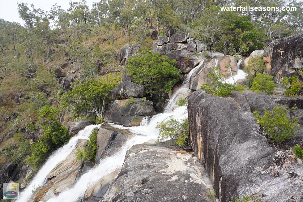
 Above: The top section of Davies Creek Falls
(Order this image)
The falls are located on a dirt road running off the National Highway between Cairns and Mareeba. The road was well maintained and suitable for 2WD vehicles on my visit.
However, there are only a handful of car spaces in a little turning circle when you arrive, so try and get there early on weekends and public holidays.
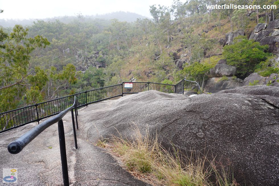
 Above: The sloping guide rail down to the viewing area at the falls
(Order this image)
The walk to the falls is well marked along a quartz gravel path that stays fairly dry, even in the rain. It has a few steps, but is otherwise easy to traverse. During moderate to high flows, there is no safe access to the creek bed at the top of the falls.
The viewing area beside the falls is readily accessible in all weather and has commanding views of the valley and surrounding mountain range, as well as a close up view of the falls.
As I mentioned, I found the closeness to the edge of the cliff a little unsettling, particularly
given the sloping boulders under foot that give you a bit too much momentum leading down to the fence. One of my fellow visitors stood at the back of the viewing area,
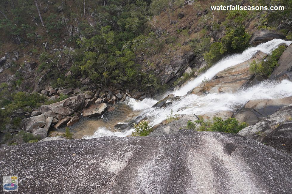
not going anywhere near the fence, because it was too unnerving. The views are however amazing and you can see all the way from the lip of the falls, down the cascade, to the little pool at the base.
 Above: The view over the edge at Davies Creek Falls
(Order this image)
When the creek flows are low and the ground is dry, it is possible to walk out onto the rock shelf at the top of the falls (with care, noting that people have slipped off the edge in the past). The walking track then continues on upstream to the designated swimming area, which has a gravel beach and a little natural pool in the creek.
View Larger Map
How high are the waterfalls at Davies Creek Falls? I estimate that they are around 20-30 metres high, but it feels higher than that from the viewing area, because you are standing on the edge of a cliff.
If you have any other questions not answered above, leave a comment for me using the comment box below.
 Above: The top section of Davies Creek Falls
(Order this image)
The falls are located on a dirt road running off the National Highway between Cairns and Mareeba. The road was well maintained and suitable for 2WD vehicles on my visit.
 Above: The sloping guide rail down to the viewing area at the falls
(Order this image)
The walk to the falls is well marked along a quartz gravel path that stays fairly dry, even in the rain. It has a few steps, but is otherwise easy to traverse. During moderate to high flows, there is no safe access to the creek bed at the top of the falls.
 Above: The view over the edge at Davies Creek Falls
(Order this image)
When the creek flows are low and the ground is dry, it is possible to walk out onto the rock shelf at the top of the falls (with care, noting that people have slipped off the edge in the past). The walking track then continues on upstream to the designated swimming area, which has a gravel beach and a little natural pool in the creek.
Your Seasonal Guide:
| Best Time of Year to Visit: | Best Time of Day to Visit: |
|---|---|
| Any time of year is fine, with the falls at their most vigorous when it rains, which can be particularly heavy and persistent during the wetter months from November to March | You might want to visit early in the day to ensure you can park your car, with any time of the day good for viewing the falls. |
Other Information Before You Go:
Location:Davies Creek Road, 23 km (approx. 20 minute drive) east of Mareeba and 57 km (approx. 1 hour drive) west of Cairns.
Latitude:-17.009844 Longitude:145.582181
Getting there: From the Kennedy Hwy (route 1) between Cairns and Mareeba, it is 8 km along Davies Creek Road to Davies Creek Falls. Only a handful of car spaces are available at the little turning circle, with the bend in the road here making it hard to park anywhere else nearby if the car park is full. The road includes sections of gravel road, that on my visit during mostly dry conditions were suitable for 2WD vehicles.
Water source: Davies Creek
Approx. height: 20-30 metres
Approx. width: 5-10 metres
Approx. length: 30 metres
Swimming available at the falls: Yes, but not where you might think. Here is more info about my swim
Facilities: Car park, falls viewing area. There are no rubbish bins, so plan to take your rubbish home with you.
Entrance fee: None
Opening times: Always open
Sun shade: Limited shade available along the track to the falls. No shade at the falls viewing area.
Wheelchair access: None
Prohibitions including whether you can bring your dog: No dogs, no cats, no camping, no fires.
Managing authority: Queensland Department of Environment and Science
Nearby attractions: Lower Davies Creek Campground, 2 km back down Davies Creek Road towards Mareeba.
Waterfall twin: Gibraltar Falls near Canberra, around 2000 km to the south, is remarkably similar to Davies Creek Falls, with its perched viewing area, granite cascade, and similar shaped pool at the bottom.
Before you head out, make sure you read the
waterfall safety information and check with the managing authority for any current change of conditions.
Specific to this site, the managing authority warns at the falls that there are sheer cliffs, slippery rocks, swift currents, and submerged objects. Natural hazards in this area combined with risky
behaviour by visitors have caused serious injuries and deaths. Stay on the track and behind the barrier at the falls, never jump or dive into the creek, avoid drinking alcohol, and supervise your
children at all times. The managing authority also recommends to avoid swimming after heavy rain or when the creek is in flood, because rapidly rising water levels make it unsafe.
Latitude:-17.009844 Longitude:145.582181
Getting there: From the Kennedy Hwy (route 1) between Cairns and Mareeba, it is 8 km along Davies Creek Road to Davies Creek Falls. Only a handful of car spaces are available at the little turning circle, with the bend in the road here making it hard to park anywhere else nearby if the car park is full. The road includes sections of gravel road, that on my visit during mostly dry conditions were suitable for 2WD vehicles.
Water source: Davies Creek
Approx. height: 20-30 metres
Approx. width: 5-10 metres
Approx. length: 30 metres
Swimming available at the falls: Yes, but not where you might think. Here is more info about my swim
Facilities: Car park, falls viewing area. There are no rubbish bins, so plan to take your rubbish home with you.
Entrance fee: None
Opening times: Always open
Sun shade: Limited shade available along the track to the falls. No shade at the falls viewing area.
Wheelchair access: None
Prohibitions including whether you can bring your dog: No dogs, no cats, no camping, no fires.
Managing authority: Queensland Department of Environment and Science
Nearby attractions: Lower Davies Creek Campground, 2 km back down Davies Creek Road towards Mareeba.
Waterfall twin: Gibraltar Falls near Canberra, around 2000 km to the south, is remarkably similar to Davies Creek Falls, with its perched viewing area, granite cascade, and similar shaped pool at the bottom.
Locality Map:
The marker indicates the approximate location of the parking area at the start of the walk to the falls. If the map is not zoomed in locally,
as can sometimes occur when loading, simply click or tap on "View Larger Map" below.
View Larger Map
Frequently Asked Questions:
How long is the walk to Davies Creek Falls? It is a 200 metre walk from the car park to the viewing area at the falls, with an 850 metre circuit loop that leads upstream and then
back to the car park.
How high are the waterfalls at Davies Creek Falls? I estimate that they are around 20-30 metres high, but it feels higher than that from the viewing area, because you are standing on the edge of a cliff.
If you have any other questions not answered above, leave a comment for me using the comment box below.
Comments:
If you would like to leave a comment about this waterfall, please fill in the comment box below.
I'm particularly interested in your experiences after visiting, and any changes in conditions, etc.
All fields are required if you would like to see your comments appear on this website.
| ← Back | Next Falls → |
| Australia | Queensland |
| Safety Info | Map |
| List of Lists | Your Support |
| Feedback | Media |
|
|
|
|
|
|
|
|
|
|
© Brad Neal 2024. All rights reserved. Here are my
affiliate links and cookies policy and opportunities to provide support to Waterfall Seasons.